


citiesabc, first_page
How Do You Compare Neighbourhoods Before Choosing Where to Live?
25 Aug 2026

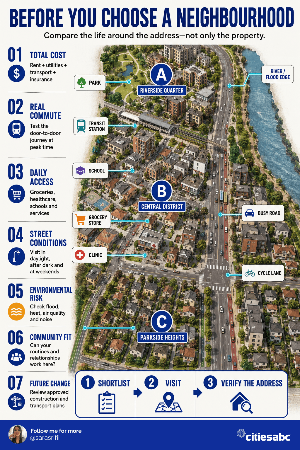
Choosing a neighbourhood is not simply a search for the lowest rent or the shortest commute. It is a decision about how everyday life will work: where time will be spent, which services will be accessible and what risks or costs may appear after moving.
The most reliable approach is to compare a small number of neighbourhoods using the same evidence, visit each one under different conditions and separate essential requirements from preferences.
Key takeaways
- Compare total monthly costs rather than rent alone.
- Test the real door-to-door commute during normal travel hours.
- Visit neighbourhoods during the day, at night and at weekends.
- Verify safety, schools and environmental risks through primary sources.
- Evaluate the exact address, not only the ZIP code or neighbourhood name.
- Use a weighted scorecard, but treat serious deal-breakers separately.
- Never transfer a deposit before verifying the property and agreement.
Begin with daily life, not online rankings
A neighbourhood described as “best” online may be unsuitable for a particular household. A quiet suburban area may work for a family with a car but isolate someone who relies on public transport. A lively central district may shorten a commute while increasing noise, rent and parking costs.
Before comparing locations, define five non-negotiables. These might include:
- Maximum total monthly housing cost
- Acceptable commute time
- Access to public transport
- Required schools or childcare
- Step-free accessibility
- Healthcare access
- Pet-friendly housing
- Reliable internet
- Low exposure to specific environmental hazards
Then identify preferences that would be valuable but are not essential, such as cafés, nightlife, parks or architectural character.
What should you compare between neighbourhoods?
| Factor | What to examine | How to verify it |
|---|---|---|
| Housing | Rent, deposit, condition and availability | Current listings, leases and property visits |
| Total cost | Utilities, insurance, transport and local fees | Provider estimates and personal calculations |
| Commute | Door-to-door time and reliability | Test journeys during working hours |
| Daily access | Groceries, healthcare, schools and services | Maps plus an in-person walk |
| Safety | Reported incidents, lighting and street conditions | Official data and repeated visits |
| Environment | Flood, wildfire, heat, air and noise exposure | Government maps and local records |
| Lifestyle | Parks, culture, restaurants and community spaces | Visit at different times |
| Future change | Construction, zoning and transport projects | Planning authority and council documents |
1. Calculate the real housing cost
Advertised rent or a mortgage payment is only the beginning. Compare:
- Utilities and internet
- Renters’ or homeowners’ insurance
- Parking and permit costs
- Transport expenses
- Building or community fees
- Laundry and storage
- Local taxes
- Expected maintenance
- Increased insurance associated with environmental risk
A less expensive property can become more costly if it requires two cars, paid parking or a long daily commute.
Citiesabc’s guide to how much money to save before moving to a new city provides a wider relocation-savings framework.
2. Test the commute rather than trusting the map
A map may show that a workplace is five miles away without revealing congestion, missed connections, limited evening services or an unsafe final walk.
Test the complete journey at the time it would normally occur. Include:
- Walking to the station or parking
- Waiting and transfer time
- Typical congestion
- Service frequency
- Cost
- Accessibility
- The return journey after dark
Remote and hybrid workers should also check internet options, mobile reception and whether the home has a realistic working space.
3. Examine access to everyday services
Search maps can show what exists nearby, but they cannot prove that a service is affordable, accessible or open when needed.
Walk from the potential home to the places likely to be used each week:
- Grocery shops
- Pharmacies
- Healthcare facilities
- Schools or childcare
- Public transport
- Parks
- Gyms or community facilities
- Restaurants and social spaces
If walking and public transport matter, Citiesabc’s analysis of the most walkable cities in the US offers broader context. Neighbourhood-level conditions must still be checked independently.
4. Investigate safety carefully
Avoid judging safety from reputation, appearance or a single online score. Crime data can be incomplete, delayed or reported at a geography larger than the neighbourhood being considered.
Review official local data and ask practical questions:
- Are streets and transit stops adequately lit?
- Is there regular pedestrian activity?
- Are crossings and pavements maintained?
- Can the route home be used comfortably after dark?
- Does the building have functioning locks and controlled access?
- Are crash-prone roads or dangerous junctions nearby?
The FBI notes that participation in its Uniform Crime Reporting programme is voluntary, so coverage can differ between agencies. Compare several sources and avoid treating one number as a complete description of a community.
5. Verify schools and childcare directly
School boundaries can change and may not follow postal neighbourhood names. Confirm the assigned school with the relevant district before committing to an address.
Consider:
- Attendance boundaries
- Capacity and enrolment rules
- Travel time
- Before- and after-school provision
- Childcare availability
- Fees and waiting lists
- Special educational support
Public ratings can provide a starting point, but they should not replace school visits, official performance data and conversations about a child’s specific requirements.
6. Check environmental and infrastructure risks
Two properties within the same neighbourhood can have different exposure to flooding, traffic noise or industrial activity.
For US locations, check the precise address against:
- FEMA flood maps
- Local evacuation and emergency plans
- Wildfire-risk information
- Air-quality monitoring
- Heat exposure and tree cover
- Water-system information
- Nearby highways, airports or industrial sites
A property outside a high-risk flood zone is not guaranteed to be flood-free. Ask about previous damage, drainage, insurance requirements and building-level protections.
7. Visit more than once
Visit each shortlisted neighbourhood:
- On a weekday morning
- During the evening commute
- After dark
- At the weekend
- During poor weather, where practical
Observe noise, traffic, lighting, parking, street activity and public-transport reliability. Spend enough time to complete an ordinary task such as buying groceries or travelling to work.
Speak with residents using neutral questions:
- What regularly causes inconvenience here?
- How reliable is public transport?
- Which costs surprise newcomers?
- What changes are planned nearby?
- How does the area feel at different times?
8. Research future development
A quiet street may have a major construction project approved nearby. An isolated district may become more accessible after a new transit connection opens.
Check local planning portals for:
- Major housing developments
- Road schemes
- Rail or bus changes
- Commercial construction
- School closures or openings
- Zoning changes
- Climate-resilience projects
Distinguish between approved, funded projects and early proposals. Future promises should not compensate for current conditions unless implementation is genuinely credible.
The Citiesabc neighbourhood comparison scorecard
Score each neighbourhood from 1 to 5 against the same criteria. Weight the factors according to their importance.
| Criterion | Suggested weight |
|---|---|
| Housing and total cost | 25% |
| Commute and transport | 20% |
| Safety and street conditions | 15% |
| Daily services | 15% |
| Environmental risk | 10% |
| Community and lifestyle | 10% |
| Future resilience | 5% |
Calculate:
Weighted score = rating × importance weight
A neighbourhood scoring 4 for housing with a 25% weight receives 1.00 weighted points.
However, do not allow an average score to hide a serious problem. An unaffordable lease, unacceptable commute or material environmental risk should remain a deal-breaker even if the location performs well elsewhere.
A practical three-stage comparison
Stage 1: Desktop research
Shortlist three to five neighbourhoods using official data, maps, listings and planning records.
Stage 2: Field testing
Visit the strongest candidates, test journeys and inspect services under different conditions.
Stage 3: Address verification
Before signing, confirm the property, landlord, lease, utilities, internet, school boundary, environmental exposure and total cost.
The broader Citiesabc relocation checklist can help organise the remaining stages of the move. After choosing a location, the guide to building a social life in a new city covers the process of establishing local connections.
Common comparison mistakes
- Comparing citywide averages instead of individual neighbourhoods
- Choosing entirely from photographs or online reviews
- Testing the commute only outside peak hours
- Ignoring utilities, insurance and transport costs
- Relying on one crime or school score
- Assuming nearby services are affordable or accessible
- Paying a deposit without verifying the property
- Treating proposed infrastructure as guaranteed
- Allowing an overall score to cancel out a serious deal-breaker
Final thoughts
The best neighbourhood is not necessarily the most fashionable or highest-rated. It is the place where housing, transport, services, safety, affordability and lifestyle work together for the household that will live there.
Use comparable evidence, visit repeatedly and verify the exact address before signing. A disciplined comparison may take longer, but it reduces the risk of discovering an expensive mismatch after the move.


