
resources
Explore California: Your Comprehensive Map for Cities and Beyond
22 Jan 2026

Thinking about a California adventure? Given its immense size, deciding where to begin can feel a bit overwhelming, can't it? This guide aims to provide a clear understanding of California’s diverse regions, from its vibrant metropolises to its untamed natural landscapes. We'll explore how to effectively use a map for California cities and surrounding areas, empowering you to confidently plan your next excursion. Whether your ideal trip involves sun-drenched beaches, majestic mountains, or simply discovering charming new towns, there's an incredible array of sights awaiting you.
Key Takeaways
- California is thoughtfully organized into distinct regions, each presenting unique sights and memorable experiences—ranging from the inviting beaches of Southern California to the imposing peaks of the Sierra Nevada.
- An expertly crafted map for California cities offers invaluable insight into the state's layout, helping you pinpoint key locations and discern how various areas seamlessly connect.
- Planning your dream California adventure becomes significantly more manageable with a map that clearly delineates cities, prominent natural landmarks, and efficient travel routes.
- The state's geographical makeup is extraordinarily varied, showcasing breathtaking coastlines, arid deserts, towering mountains, and lush, fertile valleys that are truly worth exploring.
- While major population centers like Los Angeles, San Diego, and San Francisco are undeniably prime destinations, remember to also factor in the numerous national parks and picturesque scenic drives that contribute to California's singular allure.
Navigating California's Diverse Regions
California is, without question, a state that truly defies simple categorization. Its sheer geographical scale is undeniably impressive, but it's the astonishing variety of landscapes packed within its borders that truly distinguishes it as a special haven for anyone who cherishes the outdoors. Just consider this: California proudly hosts more national parks than any other state, boasts a coastline stretching over 840 miles with countless points of access to the Pacific, and encompasses a dozen distinct regions, each possessing its own unique character. One moment you could be traversing arid desert expanses, and the next, you might find yourself amidst coastal mountains that plunge dramatically into the ocean—or perhaps in incredibly fertile valleys, then scaling the high-alpine splendor of the Sierra Nevada. It's essentially one enormous, captivating playground, and this guide—along with its accompanying map—is your essential companion for exploring every inch of it.
Southern California's Extensive Coverage
Southern California is, by any measure, an expansive area, and grasping its full scope is absolutely crucial for orchestrating your visit. This vibrant region truly stretches far and wide, extending from the sun-kissed beaches of San Diego all the way north to the massive urban tapestry of Los Angeles, then reaching even further inland. When you delve into a detailed map, you'll observe that it encompasses a multitude of counties, including Imperial, Kern, Los Angeles, Orange, Riverside, San Bernardino, and San Diego, among others. The map meticulously highlights not only the major cities but also the intricate web of road networks, the vital infrastructure that sustains these bustling areas, and the striking natural features like parks and forests that generously dot the landscape. Indeed, it's a dynamic place where vibrant urban living converges with incredibly diverse natural environments, from harsh deserts to serene mountains.
Central Coast and Valley Exploration
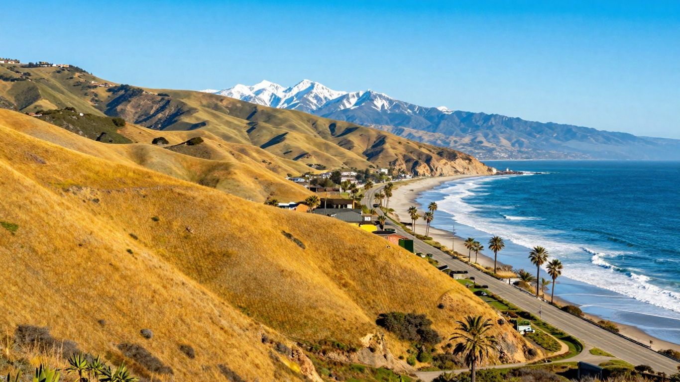
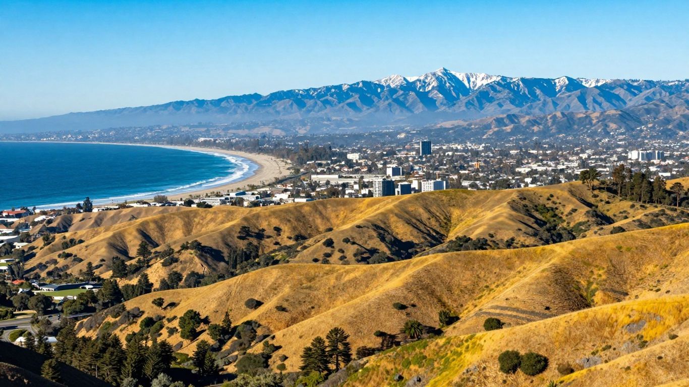
As you journey northward, the Central Coast and the Central Valley present a distinctly different, yet equally captivating, California experience. The Central Coast, globally renowned for its breathtaking Highway 1 drive, is characterized by dramatic cliffs, charming seaside towns, and unique ecosystems. Iconic locales such as Big Sur are celebrated for their delicate natural beauty, where one might be fortunate enough to spot majestic California condors soaring overhead or witness the enchanting seasonal migrations of monarch butterflies. Further inland, the Central Valley stands as the agricultural heartland of the state. Cities like Fresno serve as convenient gateways to truly incredible natural areas, including beloved national parks such as Yosemite, Kings Canyon, and Sequoia—all remarkably within easy reach. This region, then, offers a compelling blend of profound natural wonders and highly productive farmlands.
Sierra Nevada's Alpine Wonders
To the east, the Sierra Nevada mountains rise majestically, presenting a dramatic, high-altitude landscape that is nothing short of spectacular. This is truly California's premier alpine playground, home to awe-inspiring granite peaks that pierce the sky, ancient giant sequoia trees that stand as living monuments, and pristine mountain lakes whose waters reflect the surrounding grandeur. The region proudly encompasses some of the state's most famous national parks, offering unparalleled opportunities for challenging hiking, thrilling climbing, and simply—perhaps most importantly—taking in truly breathtaking views. The contrast between the gentle coastal areas and the rugged, majestic Sierra Nevada is utterly striking. It’s a place where you can immerse yourself in the raw power and sheer beauty of nature, from the depths of its canyons to its snow-capped summits.
Understanding Your California Map
Key Features for City Identification
When you first gaze upon a map of California, the sheer volume of information can seem a bit daunting, can't it? Yet, there are some straightforward methods to quickly orient yourself. Imagine the map as a giant, intricate puzzle. Cities are typically indicated by dots or small circles; generally, the larger the dot, the more significant the city. Major metropolitan areas like Los Angeles and San Francisco, for instance, will invariably stand out with bolder labels and more detailed street grids when viewed up close. Smaller towns, conversely, might simply feature a name adjacent to a modest dot. You'll also likely observe that cities tend to cluster together, particularly in regions such as Southern California or around the San Francisco Bay Area. This clustering often reveals where the majority of the population resides and, consequently, where much of the activity is concentrated.
Interpreting Regional Boundaries
California isn't merely one undifferentiated mass; it's intricately divided into distinct geographical and administrative areas, and your map is an invaluable tool for illustrating these divisions. You’ll discern various lines marking county borders—think of these as the state’s internal neighborhoods, each with its unique characteristics. Furthermore, you might notice shaded areas or different colorations that visually highlight larger, overarching regions, such as the expansive Central Valley or the majestic Sierra Nevada mountains. These boundaries aren't just arbitrary lines; they serve a crucial purpose in helping you comprehend the diverse types of environments you’re observing. For instance, a county within the Central Valley might predominantly feature agricultural land, whereas a mountainous county will clearly depict forests and peaks. Paying close attention to these lines and colors offers a rapid, intuitive grasp of an area’s landscape and distinctive character.
Utilizing the Alphanumeric Grid
Have you ever noticed those letters and numbers running along the margins of a map? That's the alphanumeric grid, and it’s an incredibly useful feature for precisely locating specific spots. Imagine you're trying to find a particular state park or a quaint small town. This grid operates much like a set of coordinates. You’ll find letters arrayed down one side (such as A, B, C) and numbers positioned along the top or bottom (like 1, 2, 3). Should you wish to locate something, the map's index will typically provide a reference, perhaps "Maple Creek - G4." You would then navigate to the column labeled 'G' and the row marked '4,' and right there, at their intersection, you'll discover Maple Creek. It’s an admirably straightforward system that effectively spares you the effort of scanning the entire map.
Here’s a quick overview of how this practical system works:
- Locate the Letter: First, find the letter on the map's edge that corresponds to the item you're searching for in the accompanying index.
- Find the Number: Next, identify the number that aligns with that specific letter.
- Intersection Point: The precise spot where the lettered column and numbered row converge marks your target area.
- Zoom In: Once you've honed in on the correct grid square, you can often discover more granular details or the exact location you're seeking.
This alphanumeric grid system is a ubiquitous feature found on many types of maps, not just those illustrating California. It stands as a universal tool for exceptionally precise location finding, significantly simplifying the process of pinpointing exact spots without getting lost in an overwhelming sea of detail.
Planning Your California Adventures
Mapping Urban Centers and Beyond
California truly is a state that offers the best of all worlds, from its sprawling, energetic cities to its serene, unspoiled natural havens. When you're poring over a map, it's quite easy to feel a little overwhelmed by the sheer multitude of options available. However, with just a bit of forethought and planning, you can strategically pinpoint and visit the places that genuinely pique your interest. Take a moment to consider what kind of journey you envision. Are you drawn to the bright lights and bustling thoroughfares of Los Angeles, or perhaps the enduring historic charm of San Francisco? Or, might you be more inclined toward the idea of exploring majestic national parks and breathtaking scenic coastlines?
The essential approach here is to connect the dots between your desired destinations and the most effective ways to reach them. This involves not only identifying major cities as potential starting points or key destinations but also understanding the fascinating landscapes and communities that lie between them. Oftentimes, some of the most memorable discoveries are made on the roads less traveled, in the quaint smaller towns or pristine natural areas you might encounter en route.
Here’s a practical way to approach your planning:
- Identify your absolute must-see spots: Make a list of the cities, parks, or attractions you are absolutely determined to visit.
- Consider your preferred travel style: Do you enjoy road-tripping, flying between distant cities, or perhaps relying on public transportation?
- Consult the map for connections: Observe how your chosen must-see spots link up. Are they conveniently located near major highways? Are there picturesque scenic routes that could connect them?
It's crucial to remember that California is an expansive state. What might appear to be a short distance on a map could easily translate into several hours of driving. Always factor in realistic travel times, especially if you're aiming to fit a lot into a shorter trip.
Visualizing Travel Routes
Once you’ve formulated a general idea of your desired destinations, the subsequent step involves determining the most effective ways to reach them. This is precisely where visualizing your travel routes becomes extraordinarily beneficial. A well-designed map will clearly display the principal highways, such as I-5, which spans north-south across the state, or the iconic Highway 101, which hugs much of the coast. Crucially, it also highlights smaller state routes and charming scenic byways that can significantly enrich your journey, transforming a mere commute into an engaging exploration.
Strive to devise a route that strikes a harmonious balance between efficiency and enjoyment. For example, if you're venturing south from San Francisco, you might choose to take Highway 1 for an utterly stunning coastal drive through regions like Big Sur—even if it necessitates a longer travel time compared to adhering to the faster inland interstates. Alternatively, if Yosemite National Park is your objective, you'll certainly want to pinpoint the most convenient access roads leading from the nearest major cities.
Here are some key considerations when meticulously planning your routes:
- Highway Numbers: Familiarize yourself with the main interstate and state highway designations. These will serve as your primary arteries for navigating the state.
- Scenic Byways: Actively seek out routes officially designated as scenic. These often meander through exceptionally beautiful areas and typically feature convenient pull-offs for photo opportunities.
- Travel Time Estimates: Utilize your map or a reliable GPS application to obtain realistic estimates for driving times between various points. Do bear in mind that these estimates can fluctuate based on traffic conditions and unforeseen road circumstances.
Discovering Points of Interest
As you meticulously plan your routes, you’ll naturally begin to spot other intriguing places along your intended path. These could encompass anything from quirky roadside attractions to serene state parks or delightfully charming small towns. California is genuinely brimming with these hidden gems, each capable of adding a distinct and memorable character to your overall trip.
Consider, for instance, that while driving through the vast Central Valley, you might suddenly notice signs beckoning you to local wineries or inviting farm stands. Or, if you’re actively exploring the captivating coastline, you might stumble upon a small beach town boasting a unique historical narrative or perhaps an exceptional seafood restaurant. These unexpected, spontaneous stops often evolve into the most cherished and memorable segments of your entire adventure.
To ensure you don’t inadvertently miss out on these delightful opportunities:
- Scan the Map: Deliberately look for symbols indicating parks, historical markers, or other points of interest situated conveniently near your planned itinerary.
- Read Roadside Signs: Maintain vigilance for roadside signs as you drive; they frequently direct travelers to fascinating local attractions.
- Use Online Resources: Many reputable travel websites and specialized apps proficiently highlight various points of interest, often including valuable local recommendations and genuine reviews.
Sometimes, the most enriching discoveries are precisely the ones you haven't meticulously planned for. Cultivate an openness to spontaneous detours—they frequently lead to the most uniquely rewarding experiences imaginable.
California's Unique Geographical Tapestry
California is a state that truly showcases the pinnacle of natural diversity. It isn't merely vast; it is incredibly varied, offering something compelling for virtually anyone who appreciates the great outdoors. Just consider its stunning array: you'll discover pristine coastlines, majestic mountains, stark deserts, and fertile valleys, all wonderfully encapsulated within a single state. This remarkable variety signifies that no matter what kind of scenery calls to your soul, you'll most likely find it here.
Coastal Landscapes and Access Points
California's magnificent coastline stretches for over 840 miles, and it's generously dotted with more than 1,150 public access points where visitors can enjoy its beaches or simply marvel at the ocean vistas. From the dramatic, rugged cliffs of Big Sur to the expansive, sandy shores of Southern California, the coast remains an enormous draw. Driving along Highway 1, for example, offers some of the most breathtaking ocean views you'll ever encounter—it's a place where the mountains frequently meet the sea in a truly spectacular fashion.
Desert Terrain and Mountain Ranges
Venture inland, and the landscape undergoes a profound transformation. California is home to vast desert regions, such as those spectacularly preserved in Joshua Tree National Park or the iconic Death Valley, both celebrated for their unique flora and austere beauty. Then, the majestic mountains emerge. The Sierra Nevada range, for instance, boasts towering peaks, pristine alpine lakes, and ancient giant sequoia trees. These mountains serve as an unparalleled playground for avid hikers, intrepid climbers, and enthusiastic skiers alike, offering an entirely different sensory experience from the coast.
Fertile Valleys and Natural Habitats
Nestled between the coastal ranges and the imposing Sierras lie California's renowned valleys, most notably the expansive Central Valley. This region is extraordinarily fertile, serving as a pivotal agricultural hub for the United States and yielding an impressive bounty of fruits, vegetables, and nuts. Beyond its agricultural prowess, these valleys and other surrounding regions actively support a wide array of natural habitats—from vital wetlands that serve as critical stopovers for migratory birds to lush forests teeming with diverse wildlife. A comprehensive understanding of these varied environments greatly enhances one’s appreciation for the state's profound ecological richness.
California's incredibly varied geography isn't just a feast for the eyes; it directly influences everything from its robust economy to the vast spectrum of recreational opportunities available. The state's abundant natural resources have indelibly shaped its history and continue to define its unique character.
Exploring California's Major Hubs
Los Angeles and Surrounding Areas
Los Angeles, affectionately known as the City of Angels, is an undeniably sprawling metropolis that stands as a global epicenter for entertainment, culture, and commerce. Its immense scale ensures there's always something new to uncover, ranging from iconic Hollywood landmarks to the diverse neighborhoods, each boasting its own distinct character. Beyond the city limits, the surrounding areas offer a compelling blend of charming coastal towns, tranquil suburban communities, and refreshing natural escapes. Planning a visit here, admittedly, can feel a bit daunting due to its sheer size, which is why a reliable map is absolutely essential. You'll certainly want to pay close attention to traffic patterns, as they can significantly impact travel times. The Los Angeles area truly is a place where you can discover everything from world-class museums and thrilling theme parks to peaceful beaches and invigorating hiking trails.
San Diego's Coastal Charm
Further south, San Diego exudes a noticeably more relaxed ambiance compared to its bustling northern counterpart. Celebrated for its exquisite beaches, consistently pleasant climate, and a significant military presence, it’s a city that gently encourages you to unwind and savor the quintessential coastal lifestyle. Balboa Park is an absolute must-see, home to numerous museums and beautifully curated gardens, while the historic Gaslamp Quarter buzzes with vibrant nightlife and exceptional dining options. The city’s close proximity to the Mexican border also imparts a distinct and rich cultural flavor. Exploring San Diego is best achieved with a clear understanding of its diverse neighborhoods, as each one offers a unique and memorable experience.
San Francisco's Cultural Enclaves
San Francisco, dramatically perched on the northern tip of a peninsula, is globally celebrated for its iconic rolling hills, the instantly recognizable Golden Gate Bridge, and an incredibly vibrant cultural scene. It's a city defined by its distinct neighborhoods—from the historic Italian charm of North Beach to the bustling, sensory-rich streets of Chinatown, famously the largest outside of Asia. Public transportation, including the renowned cable cars, is a highly popular and practical way to navigate the city, particularly given its hilly terrain and frequently congested streets. San Francisco remains a dynamic hub for innovation and technology, yet it also boasts a deep, rich history and a powerful sense of community, truly striking a unique balance.
Here are a few key areas to consider when exploring the multifaceted charm of San Francisco:
- Fisherman's Wharf: Renowned for its fresh seafood, engaging street performers, and captivating views of Alcatraz Island.
- Chinatown: A lively, vibrant district showcasing traditional architecture, bustling markets, and an authentic array of restaurants.
- Haight-Ashbury: Famous for its pivotal role in 1960s counterculture history and its collection of unique, eclectic shops.
- Mission District: Celebrated for its striking murals, rich Latin culture, and incredibly diverse culinary landscape.
When meticulously mapping out your visit to these major California hubs, it’s wise to remember that each city possesses its own distinct rhythm and unique transportation quirks. A detailed map will certainly aid in understanding the layout, but some local knowledge—or a bit of extra research—can truly make your exploration much smoother and more enjoyable.
Beyond the Cities: California's Natural Wonders
California is, in truth, so much more than just its bustling metropolises. The state proudly showcases an incredible variety of natural landscapes, offering virtually endless opportunities for outdoor enthusiasts of all stripes. From its towering mountain ranges to its vast, mysterious deserts and a truly stunning coastline, there's a natural wonder waiting for everyone to explore. Where will you begin your adventure?
National Parks and Protected Areas
California is home to an impressive nine national parks—more than any other state in the nation. These cherished parks meticulously preserve some of the most iconic and ecologically diverse ecosystems across the country. Planning a visit to these magnificent sites can, at first glance, feel quite overwhelming given the sheer number of options, but rest assured, each park promises a unique and unforgettable experience.
- Sequoia and Kings Canyon National Parks: These parks are famously known for their colossal giant sequoia trees, including the revered General Sherman Tree, which holds the title of the largest tree by volume on Earth. Beyond the ancient groves, these parks also feature deep, dramatic canyons and soaring mountain peaks.
- Yosemite National Park: A true gem, Yosemite is celebrated for its towering granite cliffs like El Capitan and Half Dome, its breathtaking waterfalls, and its own magnificent giant sequoia groves. It remains an absolute paradise for dedicated hikers and climbers.
- Death Valley National Park: A land of profound extremes, Death Valley features Badwater Basin—the lowest point in North America—alongside mesmerizing sand dunes, vast salt flats, and vividly colored mountains. It is a place of stark, yet utterly captivating beauty.
- Joshua Tree National Park: Distinguished by its unique Joshua trees and fascinating, sculptural rock formations, this park is particularly popular among rock climbers and avid stargazers.
Visiting national parks invariably requires a degree of preparation. Always remember to check the park's official website for the most current conditions, any pertinent alerts, and any required reservations before you set out. Pack appropriately for the anticipated weather and terrain, and crucially, practice Leave No Trace principles to conscientiously protect these invaluable natural areas for generations to come.
Scenic Routes and Byways
Embarking on a drive through California can be an adventure in itself, especially when you judiciously opt for one of its many renowned scenic routes. These thoughtfully designated routes are specifically designed to highlight the state's most breathtaking and diverse landscapes, making the journey as memorable as the destination.
- Highway 1 (Pacific Coast Highway): This iconic highway gracefully hugs the dramatic coastline, offering unparalleled ocean views, charming seaside towns, and convenient access to pristine beaches and state parks. Sections, such as the renowned drive through Big Sur, are globally celebrated for their awe-inspiring beauty.
- Tioga Pass Road (Highway 120): This spectacular route, winding through the majestic Sierra Nevada mountains, provides essential access to Yosemite's high country and truly stunning alpine scenery. It is typically open only from late spring through fall, owing to heavy winter snowfalls.
- State Route 395: Running majestically along the eastern flank of the Sierra Nevada, this byway offers access to invigorating natural hot springs, dramatic mountain vistas, and the unique, captivating landscapes of the Eastern Sierra.
Understanding Ecosystems and Habitats
California's incredibly diverse geography actively supports a vast array of ecosystems and habitats, each teeming with its own unique plant and animal life. A deeper understanding of these intricate environments significantly enhances one's appreciation for the state's unparalleled natural richness.
- Coastal Ecosystems: From rugged rocky shores to expansive sandy beaches and vibrant kelp forests, the California coast is literally teeming with life. Marine mammals, a wide variety of seabirds, and diverse intertidal organisms all thrive harmoniously here.
- Mountain Habitats: The Sierra Nevada and other prominent mountain ranges host magnificent forests of pine, fir, and cedar, alongside pristine alpine meadows. These elevated areas are home to black bears, various deer species, and a rich diversity of birdlife.
- Desert Environments: Regions like the vast Mojave and Colorado Deserts feature remarkable adaptations for survival, including drought-resistant plants such as cacti and creosote bush, and resilient animals like desert tortoises and bighorn sheep.
- Valley and Foothill Habitats: The fertile Central Valley and its surrounding foothills actively support expansive oak woodlands, vast grasslands, and vital riparian areas along rivers, collectively providing crucial habitats for a rich variety of wildlife and underpinning California's bountiful agricultural output.
Your California Adventure Awaits
California truly is a state brimming with endless possibilities—so much to see, so much to do, from its dynamic urban centers to its absolutely breathtaking natural wonders. Whether you're eagerly seeking a challenging hike, the thrill of surfing, or simply the joy of exploration, this map has, we trust, provided the clarity you needed to navigate your way. We've thoroughly examined the distinct regions of the state, stretching from its captivating coastlines to its majestic mountains, and outlined how you can effectively plan your next trip. Remember, California is vast and offers an incredible diversity of experiences, so don't hesitate to venture beyond the well-trodden paths. We genuinely hope this guide serves as an invaluable resource as you meticulously plan your next great California adventure. Happy travels—may they be filled with discovery and delight!
Frequently Asked Questions
What kind of map is this article about?
This article focuses on a specialized map of California. Consider it a comprehensive visual aid that meticulously outlines all the prominent cities, charming towns, and noteworthy points of interest. It's designed to help you pinpoint everything, from the inviting beaches in the south to the formidable mountains in the north.
What makes California's geography special?
California boasts an extraordinary array of diverse landscapes. You'll encounter expansive sandy beaches along its extensive coastline, arid deserts, towering mountain ranges like the majestic Sierra Nevada, and incredibly fertile valleys where a significant portion of the nation's food is grown. It truly feels like many distinct places are all wonderfully rolled into one cohesive state!
Can this map help me plan a road trip?
Yes, absolutely! The map is an indispensable tool for visualizing road networks and understanding how various cities and towns are connected. It empowers you to strategically plan the most efficient and enjoyable routes for traversing different parts of California, whether your interest lies in its bustling major cities or its awe-inspiring natural landmarks.
What are the main areas covered by the map?
The map provides comprehensive coverage of California's key regions. This includes the dynamic Southern California area, featuring major hubs like Los Angeles and San Diego, as well as the picturesque Central Coast and Valley, and the high-altitude wonders of the Sierra Nevada mountains. It also prominently highlights other significant urban centers, such as San Francisco.
Does the map show natural places like parks?
Most definitely! Beyond its urban centers, the map meticulously identifies crucial natural areas. You can locate national parks, plan scenic drives, and gain a clearer understanding of the diverse environments—like dense forests, expansive deserts, and captivating coastlines—that collectively contribute to California's unique ecological identity.
How can I use the map to find specific places?
The map incorporates highly useful navigational aids, such as an alphanumeric grid system and a detailed index. These features function much like a coordinate system or a directory, greatly simplifying the process of pinpointing exact cities, towns, or specific points of interest you're searching for, thereby ensuring you can find your way with confidence.


