
resources
Explore the World in Stunning Detail with our New 3D Map
11 Dec 2025

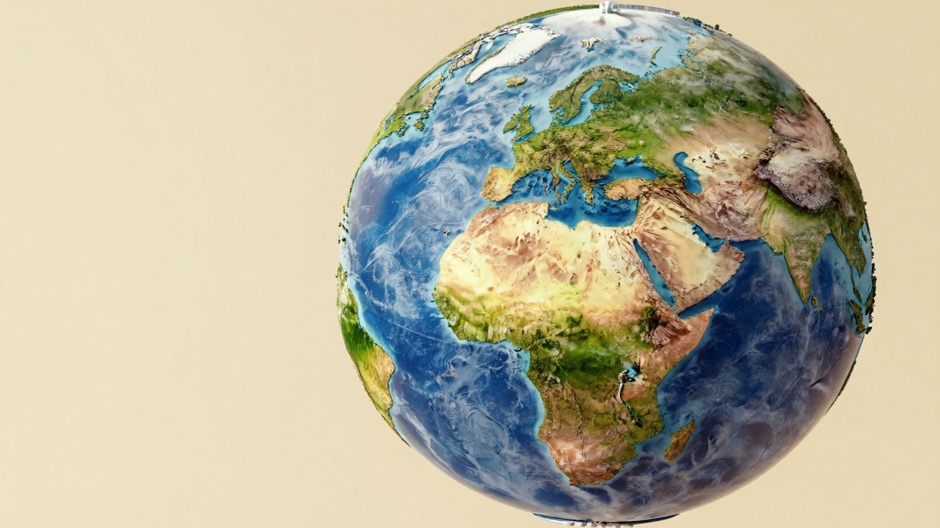
Have you ever sought a truly immersive way to perceive our world, moving beyond the confines of traditional flat maps? We believe we've found an exceptional solution: an innovative 3D world map tool that redefines how you explore the globe. Far more dynamic than a static representation, it functions as a highly interactive digital globe, allowing you to seamlessly zoom in with incredible precision or pull back for a sweeping planetary view. This transforms trip planning and geographical discovery into a far more engaging experience. While incredibly sophisticated, the tool is remarkably intuitive, making global exploration accessible to everyone, regardless of technical prowess. It offers an unparalleled opportunity to traverse the world virtually, a perfect escape for those moments when physical travel isn't possible.
Key Takeaways
- Gain a fresh perspective on the world through an interactive 3D globe.
- Visualize authentic locations with detailed satellite imagery and three-dimensional views.
- Immerse yourself in cities, natural landscapes, and even historical sites up close.
- Effortlessly plan future travels or acquire fascinating insights about diverse global destinations.
- This 3D world map tool is designed for universal ease of use.
Experience Earth Like Never Before With Our 3D World Map
Immersive 3D Globe Exploration
Prepare to engage with our planet in an entirely novel fashion. Our 3D world map transcends a mere flat representation; it is, in fact, a dynamic globe that you can rotate, zoom, and explore with extraordinary fidelity. Imagine holding Earth in the palm of your hand, capable of scrutinizing a minuscule island or retracting to encompass entire continents. This level of interaction renders geographical learning less a task and more an authentic adventure. You can genuinely appreciate the sheer scale and profound beauty of our world when you observe it curving and turning right before your very eyes.
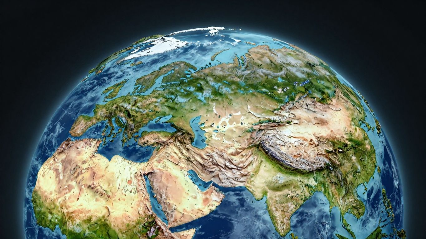
High-Resolution Satellite Mapping
We've meticulously integrated some of the finest satellite imagery available to present you with views that are both precisely accurate and visually breathtaking. Upon zooming in, you'll uncover unprecedented detail—from the intricate networks of urban streets to the rugged, textured contours of mountain ranges. This goes beyond providing aesthetically pleasing visuals; its core purpose is to offer a clear, current depiction of Earth's surface. Consider it a live, digital portal to any location on the planet, revealing its true nature with remarkable clarity and definition.
Seamless Switching Between Map Views
A comprehensive understanding of any locale frequently necessitates viewing it from multiple perspectives. Consequently, our map enables you to transition effortlessly between the immersive 3D globe perspective and conventional satellite imagery. One moment, you might be admiring the spherical grandeur of Earth; the next, you could be examining a detailed, two-dimensional satellite view of a specific region. This inherent flexibility ensures you can access the precise information you require, whether your interest lies in the overarching morphology of a continent or the granular layout of a particular neighborhood. It truly empowers you with the tools to visualize the world exactly as you wish to.
Uncover Global Details With Our Interactive 3D Earth Map
Our 3D Earth Map is far more than a collection of attractive visuals; it stands as a robust instrument for achieving a profound understanding of our planet. Users can effortlessly zoom in on specific points or retract for a broader, comprehensive outlook, all while retaining incredible detail. It truly functions as a high-powered atlas, readily available at your fingertips.
Explore Cities, Landscapes, and Landmarks
Have you ever desired to view the Eiffel Tower from an aerial perspective, or perhaps grasp the sheer magnitude of the Grand Canyon? Our map facilitates precisely that. You can virtually traverse bustling city streets, marvel at towering mountain ranges, and admire renowned architectural wonders from angles previously unimaginable. This proves to be an excellent method for familiarizing yourself with destinations long before contemplating a physical visit.
Discover Diverse Terrains and New Places
From the luxuriant Amazon rainforest to the arid expanse of the Sahara Desert, our map meticulously showcases the astonishing variety of Earth's surface. Users can readily switch between different views to observe how landscapes transform. This interactive exploration not only aids in discovering new locales but also in comprehending the unique characteristics that define various regions. It's an exceptional means to satisfy your global curiosity—and perhaps even pinpoint your next adventure destination. For an even more detailed look at human-made structures, we recommend exploring the GlobalBuildingAtlas.
Gain Fascinating Geographical Insights
Beyond merely observing places, our map furnishes a wealth of compelling facts and information. Delve into the highest peaks, the longest rivers, or the most densely populated cities worldwide. It offers an educational experience that genuinely brings geography to life. Among the discoveries you can make are:
- Major mountain ranges and their respective highest elevations.
- The trajectories of significant rivers and their profound influence on surrounding territories.
- Population densities across diverse urban centers.
- Unique geological formations and their intriguing origins.
Understanding Earth's geography extends far beyond simply memorizing names and locations. It involves appreciating the powerful forces that shape our planet and the intricate ways they influence life on its surface. Our 3D map renders this learning process both engaging and readily accessible for everyone.
Whether you are a dedicated student, an avid traveler, or simply an individual with an insatiable curiosity, this map presents an innovative avenue for connecting with the world around us.
Navigate Your World With Advanced 3D Mapping Features
Visualize Routes and Adventures in Dynamic 3D
Imagine meticulously planning your next road trip or hiking expedition and witnessing it unfold before your very eyes in three dimensions. Our advanced 3D map technology animates routes and journeys, affording you a truly comprehensive grasp of the terrain, elevation shifts, and the overall landscape. This transcends merely viewing a flat line; it's about viscerally experiencing the path ahead. You can observe mountains ascending and valleys descending, thereby gaining a far superior understanding of the journey's intricacies. Such capabilities transform the planning stage itself into an exciting exploration.
Advanced Route Planning Tailored to Your Needs
Navigating from point A to point B often involves more than simply identifying the shortest distance. Our sophisticated system allows you to meticulously customize your routes based on what truly matters most to you. Are you prioritizing the most scenic drive, the quickest way to circumvent traffic, or perhaps a path specifically suited for an activity like cycling or walking? Our platform is designed to ascertain these optimal choices. The system leverages intelligent algorithms to propose the most suitable options, taking into account a myriad of factors to precisely match your preferences. It's akin to possessing a personal travel planner with an intimate knowledge of every road and trail.
Detailed Location Insights for Every Search
When you conduct a search for a particular location, you receive more than a mere pin on a map. We furnish invaluable details designed to facilitate informed decision-making. This encompasses critical information such as business operating hours, insights into local landmarks, and even specific pricing for services like electric vehicle charging stations. This granular level of detail ensures you can plan your stops and activities with utmost confidence, secure in the knowledge that you possess the most pertinent information at your disposal. Ultimately, it aims to render your exploration both smoother and significantly more productive.
Planning a trip can, at times, feel genuinely overwhelming; however, having access to tools that illustrate precisely what to anticipate makes an immense difference. Visualizing your route in dynamic 3D, receiving personalized directions, and having all crucial details about your destinations readily available can transform a potentially stressful task into an exhilarating component of the adventure.
For your convenience, here is an overview of some key planning features:
- Dynamic 3D Route Visualization: Witness your intended path rendered in full three dimensions.
- Activity-Based Routing: Obtain directions specifically optimized for driving, cycling, walking, and diverse other activities.
- Real-Time Information: Access up-to-the-minute details for various locations and essential services.
- Customizable Preferences: Tailor route suggestions precisely to your unique requirements.
This advanced mapping technology is meticulously engineered to enhance the ease and enjoyment of your travels, whether you are organizing a local excursion or an extensive cross-country expedition. You can comprehensively explore different areas and acclimate yourself to their characteristics before ever departing from home, which is quite advantageous. For a deeper understanding of these capabilities, consider exploring how 3D Maps are now generally available for web applications.
Enhance Your Understanding With Educational 3D Maps
Our 3D map transcends mere visual appeal; it stands as a truly invaluable educational resource. We've meticulously integrated features designed to make comprehending geography, history, and even biology more engaging for all ages, from young learners to adults. Essentially, it functions as an interactive digital textbook, ripe for exploration.
Interactive Visualizations for All Ages
We firmly believe that learning should inherently be an enjoyable process. To that end, our map incorporates vivid 3D models of renowned landmarks and diverse wildlife. You can effortlessly zoom in on the iconic Eiffel Tower or observe a woolly mammoth roaming within its ancient habitat—it’s an excellent way to gain an intuitive sense of different places and historical periods. Furthermore, we feature a dedicated section exploring human evolution, vividly illustrating the lives of our ancestors. It truly offers a captivating visual journey through time, animating historical narratives.
Fascinating Facts About Countries and Cultures
Beyond the compelling visuals, we have curated a comprehensive repository of information. Upon selecting a country or a city, you will uncover intriguing details pertaining to its populace, its historical trajectory, and its distinct cultural heritage. It's akin to carrying a continually updated, pocket-sized encyclopedia. Among the myriad facts you can discover are:
- The capital cities situated on every continent.
- Major historical events inextricably linked to specific geographical locations.
- Unique cultural traditions from across the globe.
This form of interactive learning is instrumental in forging connections between abstract concepts and tangible, real-world places, thereby rendering information more memorable and profoundly meaningful.
Explore Prehistoric Life and Human Evolution
Have you ever contemplated the appearance of a dinosaur up close, or pondered the daily existence of early humans? Our map facilitates precisely that exploration. We provide meticulously detailed 3D reconstructions of prehistoric creatures and early human species. You can delve into the Jurassic period or meticulously trace the intricate path of human development—it offers a unique pedagogical approach to paleontology and anthropology. For those seeking a more profound understanding of how we perceive and analyze our planet, exploring resources on spatial thinking can prove highly beneficial.
| Era | Features |
|---|---|
| Prehistoric | Dinosaurs, mammoths, saber-toothed tigers |
| Early Humans | Neanderthals, Homo erectus, early Homo sapiens |
| Ancient Civilizations | Pyramids, Roman Colosseum, Great Wall of China |
This robust educational dimension firmly establishes our 3D map as an indispensable resource for students, educators, and anyone with an inquisitive mind.
Discover the World Through Our 3D Map Technology
Our sophisticated 3D map technology is meticulously engineered to project the world onto your screen with unparalleled detail and remarkable ease of use. It effectively functions as a virtual passport, granting you the ability to explore destinations you've only dreamed of—all without ever leaving your present location. We have prioritized creating an experience that feels as authentic as possible, enabling you to truly appreciate the planet's diverse and breathtaking beauty.
Bird's-Eye Views of Cities and Natural Wonders
Imagine the exhilaration of soaring above the Eiffel Tower or gazing down into the majestic Grand Canyon. Our system delivers truly stunning aerial perspectives that render even familiar places entirely fresh and novel. You can zoom in on vibrant cityscapes, discerning individual buildings and street layouts, or smoothly pan across expansive natural landscapes, fully grasping the sheer scale of mountains, rivers, and coastlines. This exceptional level of detail is a testament to advanced mapping techniques, including cutting-edge technologies like GeoSplats, which are instrumental in generating highly intricate 3D models.
Virtual Travel Experiences from Your Device
This platform offers more than a static map; it provides genuine experiential journeys. Our 3D map facilitates virtual travel, allowing you to immerse yourself in various regions as if you were physically present. You can wander through ancient ruins, admire contemporary architecture, or simply acquaint yourself with the spatial organization of a new city. It serves as an invaluable tool for planning future trips, delving into diverse cultures, or simply satisfying your inherent curiosity about the world.
User-Friendly Interface for Effortless Navigation
We firmly understand that powerful technology must inherently be straightforward to operate. It is for this reason that we have developed an interface that is both intuitive and exceptionally easy to navigate. Whether you possess advanced technical acumen or are entirely new to digital mapping, you will find the processes of zooming, panning, rotating, and exploring to be remarkably simple. Our core objective is to eliminate any barriers between you and your geographical discoveries, thereby ensuring the exploration process is both enjoyable and universally accessible.
Your Personal Travel Companion: The 3D World Map
Consider our 3D World Map an indispensable ally for all your travel aspirations, whether you're meticulously planning an extensive journey or simply indulging in armchair exploration. It has been meticulously crafted to be profoundly personal, enabling you to customize the map according to your most significant interests. This map transcends merely visualizing the world; it empowers you to truly make it your own.
Personalize Your Map with Custom Points-of-Interest
Have you ever wished for the ability to digitally mark your favorite cafes, the most scenic hiking trails you've discovered, or even important client addresses for professional purposes? Now, you can. Our map allows you to seamlessly add your own custom points-of-interest (POIs). Imagine the convenience of importing all those personally significant locations directly into the application. You can cultivate your own curated collection of essential spots, thereby making the map uniquely yours—a digital compendium of all the places you cherish or need to recall.
Offline Map Access for Remote Exploration
Occasionally, the most rewarding adventures lead one off the beaten path, to areas where cellular service becomes a distant memory. This is precisely where our offline map functionality proves invaluable. You can pre-download maps and 3D scenes, ensuring continuous coverage even in the most remote locales. The concern of losing your way while exploring uncharted territories can thus be entirely alleviated.
Privacy-Focused Design for Secure Navigation
We fully acknowledge and respect that your location data is inherently personal. Consequently, we have engineered this map with privacy as a paramount consideration. Our design rigorously ensures that your data and location information remain secure at every juncture of your usage. You can embark on your explorations with unwavering confidence, assured that your personal information is thoroughly protected.
Your World, In Your Hands
In conclusion, our innovative 3D map tool offers more than a mere visual representation of places; it provides a direct, interactive window to the entire planet. You can meticulously examine cities, majestic mountains, and even gain an extraterrestrial perspective on global features. It proves remarkably effective for meticulous trip planning, enriching geographical education, or simply satisfying one's inherent curiosity about the vastness of our world. We contend that it represents an exceptional means to foster a deeper connection with the world, all from the convenience of your computer or mobile device. We encourage you to explore its capabilities and discover the wonders that await.
Frequently Asked Questions
What makes this 3D map different from other map apps?
Our 3D map offers an unparalleled global perspective, allowing you to engage with the world in an entirely new dimension. Imagine manipulating a virtual globe directly on your screen, with the ability to zoom in extensively to observe cities and mountain ranges in exquisite detail. It functions as a sophisticated atlas, bringing the entire planet to life, showcasing everything from intricate street networks to vast mountain formations with clear, high-resolution satellite imagery.
Can I use this map to plan trips or find directions?
Absolutely! This map is an excellent tool for trip planning. You can visualize routes and trails in 3D, which provides a significantly enhanced understanding of the terrain. The application also intelligently suggests optimal paths, taking into account factors like topography or specific activities such as hiking or driving. Furthermore, it offers a wealth of valuable information about any location you search for.
Is this map good for learning about the world?
Indeed, it is an outstanding educational resource! Users can explore fascinating 3D models of famous landmarks and even diverse animal species. The map is replete with intriguing facts about various countries, their unique cultures, and even insights into ancient life, including dinosaurs and early human civilizations. It transforms the study of geography and history into a truly engaging experience for all ages.
What if I don't have internet access?
Internet connectivity is not always a prerequisite. You have the option to download maps and 3D views in advance. This ensures you can continue to explore and navigate even when you find yourself in areas without Wi-Fi or cellular service. It's like having a dependable guide readily available, irrespective of your location.
Can I save my favorite places on the map?
Certainly! Consider this 3D map your personalized travel assistant. You are empowered to mark and save your preferred locations—be it a beloved restaurant or a destination you intend to revisit—directly on the map. This feature helps you maintain a comprehensive record of all places that hold significance for you.
Is my personal information safe when using this map?
We prioritize your privacy with utmost seriousness. The application has been meticulously designed to safeguard your data and location information throughout your usage. You can confidently explore and navigate, secure in the knowledge that your personal details are maintained in a protected and private manner.


