
resources-malaysia
Exploring the Malaysia Map of the World: Location, Geography, and Global Context
04 Dec 2025

Have you ever wondered where exactly our country, Malaysia, sits on the grand world map? It's a nation with a fascinating geography, neatly split into two distinct parts. This article will unpack its location, explore the diverse lay of the land, and see how it all connects on a global scale. Let's take a closer look at the Malaysia map of the world and get a much clearer picture.
Key Takeaways
- Nestled in the heart of Southeast Asia, Malaysia is composed of two primary landmasses: the familiar Peninsular Malaysia and East Malaysia over on the island of Borneo.
- The country's geography is a rich tapestry, featuring everything from coastal plains and rolling hills to a mountainous interior, all crisscrossed by vital river systems and lakes.
- Malaysia shares land borders with Thailand and Indonesia, and maritime boundaries with neighbours like Singapore and Brunei, while also being a key voice in territorial discussions in the South China Sea.
- As a sizeable nation by area, Malaysia holds a significant position on the world stage, blessed with natural resources such as oil, gas, and timber, and stands as a leading producer of palm oil.
- Administratively, the country is organised into states and federal territories, with a clear distinction between the divisions on the Peninsula and in East Malaysia, which in turn shapes population patterns and the growth of our urban centres.
Understanding Malaysia's Position on the World Map
Southeast Asian Archipelago Location
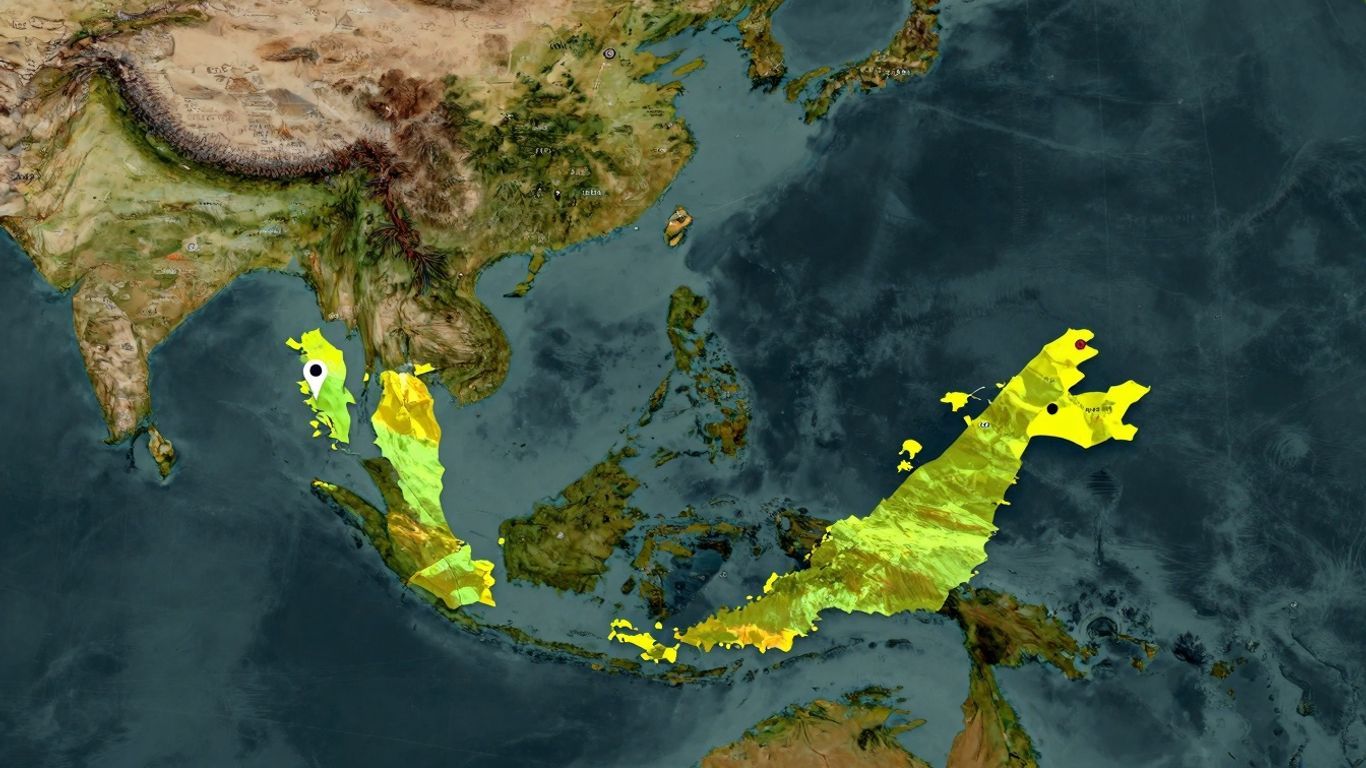
Malaysia finds its home right in the bustling heart of Southeast Asia. It's not one continuous piece of land, however. Picture it as two main regions separated by a vast expanse of water—the South China Sea. The first, Peninsular Malaysia, occupies the southern tip of the Malay Peninsula, serving as the tail end of mainland Asia. The other, East Malaysia, is situated on the remarkable island of Borneo. This unique arrangement means Malaysia is a country of both mainland and island territories, which is pretty special, isn't it?
Bridging Peninsular Malaysia and East Malaysia
So, what connects these two halves? In truth, there's no land bridge between them; the South China Sea acts as the great divider. Peninsular Malaysia lies south of Thailand and just north of Singapore. East Malaysia, on the other hand, covers a significant portion of northern Borneo, sharing borders with Indonesia's Kalimantan and the nation of Brunei. It’s a bit like having two distinct family homes, each with its own character, yet both part of the same beloved country. This separation by sea is a defining characteristic of Malaysia's geography.
Strategic Maritime Significance
Because Malaysia is split into two and is largely surrounded by water, it plays a crucial role in global maritime activities. The Strait of Malacca, flowing between Peninsular Malaysia and the Indonesian island of Sumatra, is one of the most hectic shipping lanes on the planet. Think of it as a massive, non-stop highway for cargo ships—that’s the scale we’re talking about. This strategic location makes Malaysia a pivotal player in trade and logistics across Asia and beyond, and also means the country has an extensive coastline to look after.
Malaysia's geographical split isn't just a trivial detail on a map; it profoundly shapes the nation's operations, the way its people connect, and its overall importance on the world stage. It's a country that truly bridges continents and seas.
The Diverse Geography of Malaysia
Malaysia's landscape is truly something to behold, divided into two main regions that offer quite different experiences. You have Peninsular Malaysia, the southern stretch of the Malay Peninsula, and then there's East Malaysia, situated on the vast island of Borneo. While the South China Sea separates them, both regions share a similar geographical pattern: coastal plains that gradually ascend into hills and, eventually, mountains.
Peninsular Malaysia's Topography
On the peninsula, the terrain quickly becomes hilly. In fact, more than half of the land rises above 150 metres (about 492 feet). The geology here is a combination of granite and other igneous rocks, with older stratified rocks also forming a significant part of the landscape. The western coast is where you'll find the best natural harbours, and the most fertile land is often found where rivers meet the sea. These coastal plains along the Strait of Malacca are where the majority of the population resides—and it's also home to Kuala Lumpur, our nation's capital. It's a bustling hub, that's for sure.
East Malaysia's Borneo Landscape
Over in East Malaysia, the geography feels a bit more rugged and varied. You begin with the coastal regions, naturally, but these soon give way to hills, valleys, and a deeply mountainous interior. Only a couple of major cities, Kuching and Kota Kinabalu, are found here. Southern Sarawak is predominantly low-lying coastal terrain, but as you journey northward, the land rises into plateaus and culminates in the towering mountains of Sabah. It offers a wilder, more untamed atmosphere compared to the peninsula.
Coastal Plains and Mountainous Interiors
Across both halves of Malaysia, this consistent pattern of coastal lowlands yielding to higher ground is a defining feature. The total land area is quite large, placing Malaysia as the 66th largest country in the world. What makes it unique is its territory on both mainland Asia and the Malay Archipelago. Peninsular Malaysia contributes about 40% of the country's total landmass, while the larger East Malaysia makes up the remaining 60%. The nation also boasts an impressive coastline that stretches for thousands of kilometres. This varied terrain, from flat coastal areas to formidable mountain ranges, influences everything from settlement patterns to the distribution of natural resources. It truly is a land of striking contrasts. You can delve deeper into the climate variations that affect these regions by reading about Malaysia's geography.
The country's landmass is geologically ancient, with rocks that date back hundreds of millions of years. This old foundation has been shaped by immense geological forces over eons, contributing to the rich mineral deposits and diverse topography we see today.
Navigating Malaysia's Borders and Neighbors
Malaysia's location is quite strategic, positioned right in the heart of Southeast Asia. It's not a single, solid landmass either. We have Peninsular Malaysia, the part extending down from the Asian mainland, and then East Malaysia, which is part of the island of Borneo. These two regions are separated by the South China Sea, a waterway of immense importance for global shipping.
Land Borders with Thailand and Indonesia
On the peninsula, Malaysia shares a land border up north with Thailand. This boundary was formally established way back in 1909, when Siam (as Thailand was then known) ceded several territories to the British. Over in Borneo, East Malaysia shares a very long land border with Indonesia's Kalimantan region. This border meanders through the island's interior, creating a complex and fascinating frontier.
Maritime Boundaries with Singapore and Brunei
When it comes to Singapore and Brunei, our connections are mostly across the water. The Johor Strait forms a natural maritime boundary between Peninsular Malaysia and Singapore, a busy channel bridged by the well-known Johor-Singapore Causeway. With Brunei, Malaysia's border is largely maritime, though a small land border also exists. Any historical territorial questions, such as Brunei's past interest in Limbang in Sarawak, have long been settled through peaceful negotiations.
South China Sea Territorial Disputes
The South China Sea is where things get a bit more intricate. Malaysia has its own claims in these waters, extending 12 nautical miles for its territorial sea and a much larger exclusive economic zone beyond that. But we're not the only ones. Several other nations—including China, the Philippines, Vietnam, and Taiwan—also have overlapping claims, particularly around the Spratly Islands. This makes the South China Sea a focal point for ongoing dialogue and, at times, diplomatic disagreements over sovereignty. It's a vast area rich in resources and crucial shipping lanes, so it's understandable why it commands so much attention.
Malaysia's geography means it's surrounded by sea on most sides, with just a couple of land-based neighbours. This unique position shapes many of its international relationships, both across shared borders and through bustling sea lanes.
Key Geographical Features of Malaysia
Malaysia is a country with a truly interesting geography, spread across two main territories separated by the sea. It's certainly not all flat land; there's a great deal of variety to explore!
Major Rivers and Lakes
Our rivers and lakes are the lifeblood of the country. The Rajang River is the longest, majestically winding its way through Sarawak. Then there's Tasik Kenyir, an enormous man-made lake, while Tasik Bera holds the title of the largest natural lake. These bodies of water are absolutely vital for local communities and the surrounding ecosystems.
Highest Peaks and Lowest Points
When it comes to elevation, Mount Kinabalu wears the crown. It is the highest peak in Malaysia, soaring to a breathtaking 4,095.2 metres. At the other end of the spectrum, the country's lowest point is simply the sea level of the Indian Ocean, at 0 metres. It’s pretty remarkable that Malaysia encompasses such a dramatic range, from towering summits to the vast, open ocean.
Island Geography and Coastline Length
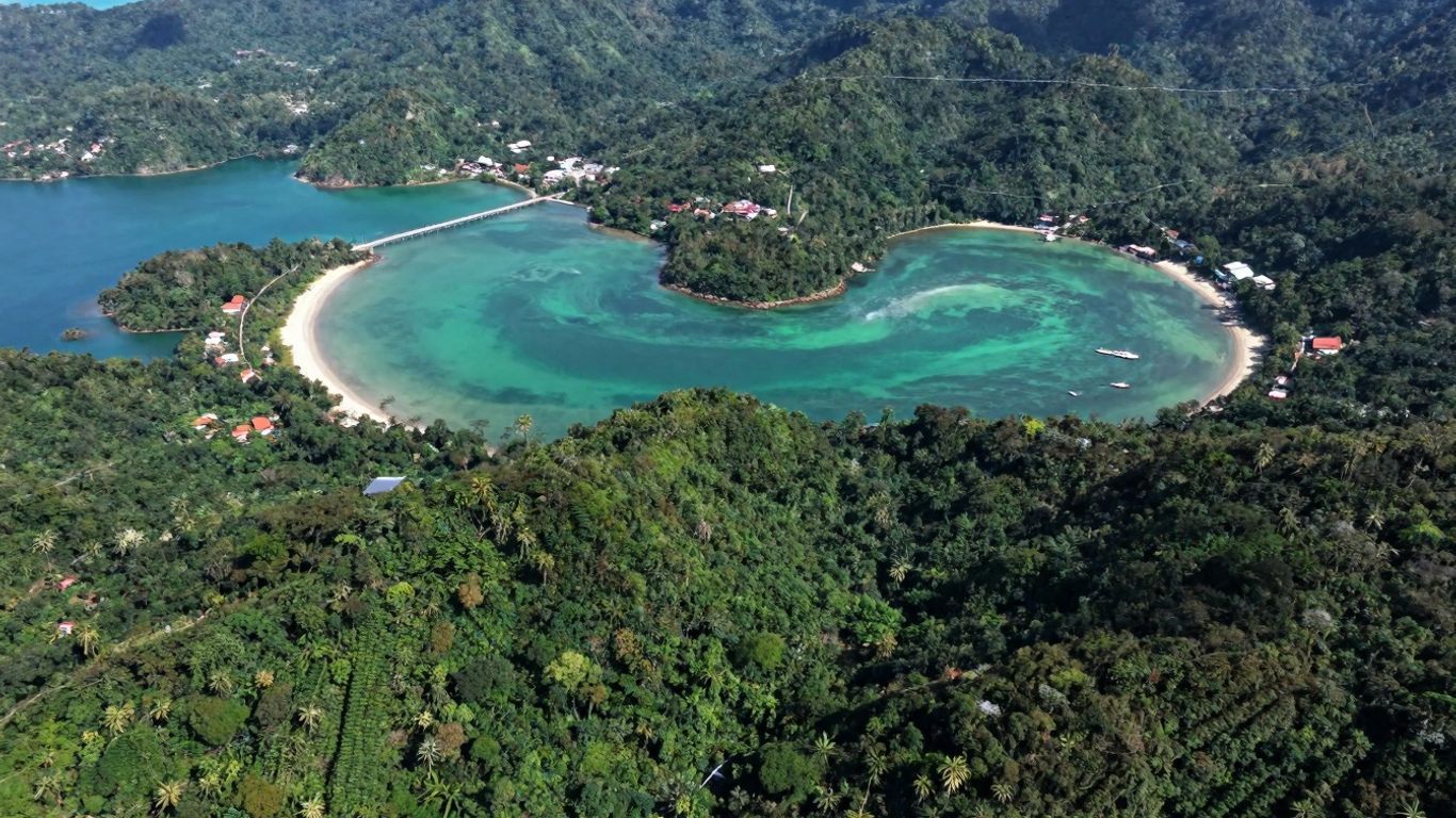
Malaysia has a truly extensive coastline, stretching for approximately 4,675 kilometres. Peninsular Malaysia claims a significant portion of this, but East Malaysia actually has the longer shoreline. The country is also dotted with countless smaller islands. This vast interaction with the sea shapes everything from our weather patterns to local economies, and it’s a huge part of what makes both Peninsular Malaysia and East Malaysia so unique.
The nation's landmass rests on the Sunda Shelf and is geologically quite stable. The oldest rocks here are ancient, dating back half a billion years, with limestone being a common feature. These geological foundations have played a crucial role in shaping the land and even influencing the location of resources like oil and gas, particularly in East Malaysia.
Malaysia's Place in the Global Context
Area Ranking and Landmass Comparison
So, how do we stack up in size on the world stage? Malaysia ranks around 67th globally in total area, covering approximately 330,803 square kilometres of both land and water. To put that into perspective, our country is slightly smaller than the US state of New Mexico but larger than Italy. This size gives Malaysia a substantial presence in Southeast Asia without being one of the region's absolute giants.
Natural Resources and Economic Geography
Malaysia is blessed with an abundance of natural resources. Tin, petroleum, natural gas, and timber have long been cornerstones of our economy. While the country has successfully diversified into manufacturing and services, these raw materials remain fundamentally important. Our location is also a major economic advantage—sitting right along critical shipping routes like the Strait of Malacca. This prime position facilitates trade and transport, a massive boon for any nation's economic health.
Biodiversity Hotspot and Environmental Considerations
This is an area where Malaysia truly stands out. It is recognised as a megadiverse country, home to an incredible variety of plant and animal species, many of which are found nowhere else on Earth. This is particularly true for the ancient rainforests of Borneo. However, this natural wealth comes with significant responsibilities. Deforestation, habitat degradation, and the effects of climate change are pressing concerns. Protecting these unique ecosystems is a monumental task, not just for Malaysia's future, but for the well-being of the entire planet.
Malaysia's strategic position across major sea lanes, combined with its rich natural endowments, has profoundly shaped its economic journey. The nation's commitment to conservation, even as it faces environmental pressures, underscores its vital role in global ecological conversations.
Administrative Divisions on the Malaysia Map
Federal Territories and States
Malaysia isn't governed as one single entity; it's more like a mosaic made up of smaller, distinct pieces. The country is composed of thirteen states and three Federal Territories. You can think of the Federal Territories as special zones managed directly by the central government. Eleven states and two of these territories are located on Peninsular Malaysia. The remaining two states and one Federal Territory are situated far to the east, making up East Malaysia. Each state and territory has its own internal structure, typically divided into districts, though Sabah and Sarawak use a system of 'divisions' as a higher-level subdivision.
Peninsular vs. East Malaysia Divisions
This division between Peninsular Malaysia and East Malaysia is more than just geographical—it's a fundamental aspect of the country's administrative framework. Peninsular Malaysia is home to the majority of the states (eleven in total) plus the Federal Territories of Kuala Lumpur and Putrajaya. East Malaysia, conversely, comprises the two large states of Sabah and Sarawak, along with the Federal Territory of Labuan. This separation is a key feature to understand when looking at a map and grasping the nation's structure.
Urban Centers and Population Distribution
If you look at a population map of Malaysia, you'll quickly notice that people aren't spread out evenly. A significant majority of Malaysians live in urban areas, with a few major cities dominating the landscape. Kuala Lumpur, our capital, is by far the largest city. Other key urban hubs include George Town in Penang, Johor Bahru in the south, and cities in Selangor such as Subang Jaya and Klang. Over in East Malaysia, Kota Kinabalu in Sabah and Kuching in Sarawak serve as the main population centres. These cities are the vibrant economic and social hearts of their respective regions.
Here’s a quick look at some of the country's larger urban areas:
| City/Municipality | State/Federal Territory |
|---|---|
| Kuala Lumpur | Federal Territory |
| Subang Jaya | Selangor |
| Seberang Perai | Penang |
| Klang | Selangor |
| Johor Bahru | Johor |
| Shah Alam | Selangor |
| George Town | Penang |
| Petaling Jaya | Selangor |
| Kota Kinabalu | Sabah |
| Malacca City | Malacca |
The way Malaysia is divided for administrative purposes clearly reflects its unique geography, with a distinct separation between the peninsular and island territories. This structure influences everything from governance to the daily lives of people across different regions.
Wrapping It Up
So, when you see Malaysia on a world map, it's so much more than just a spot in Southeast Asia. It's a nation with a remarkable blend of land and sea, strategically located in one of the world's most dynamic regions. From its majestic mountains and winding rivers to its extensive coastlines, the country's geography has profoundly shaped its identity and story. Furthermore, its location places it at the crossroads of global trade, giving it a unique and vital role in the region. It's truly fascinating to see how all these geographical pieces come together to make Malaysia the incredible place it is today.
Frequently Asked Questions
Where exactly is Malaysia located on a world map?
Malaysia is located right in the heart of Southeast Asia. It consists of two main regions: Peninsular Malaysia, which hangs off the southern tip of the Malay Peninsula, and East Malaysia, which is on the northern part of Borneo island. The South China Sea separates these two parts.
What kind of landforms does Malaysia have?
Oh, Malaysia's landscape is incredibly diverse! You'll find coastal plains and mountain ranges in Peninsular Malaysia. Over in East Malaysia on Borneo, there are also coastal areas, rolling hills, and a much more rugged, mountainous interior. The country is also rich with rivers and lakes, the longest river being the Rajang River in Sarawak.
Which countries share borders with Malaysia?
On land, Malaysia shares a border with Thailand to the north of the Peninsula, and a long border with Indonesia on the island of Borneo. We also have maritime boundaries with our neighbours, including Singapore and Brunei.
What are some important geographical features in Malaysia?
Some of the key features are the very long coastlines of both Peninsular and East Malaysia, the mountainous interiors, and major rivers like the Rajang. Of course, the highest peak is the magnificent Mount Kinabalu in Sabah. Malaysia is also surrounded by numerous beautiful islands.
How big is Malaysia compared to other countries?
By land area, Malaysia is ranked about 67th in the world. To give you an idea, it's larger than countries like the UK but smaller than nations like Vietnam. It’s quite unique because it has territory on both mainland Asia and in the Malay Archipelago.
How is Malaysia divided into different regions?
Administratively, Malaysia is divided into thirteen states and three Federal Territories. You'll find eleven states and two Federal Territories in Peninsular Malaysia, while the remaining two states and one Federal Territory make up East Malaysia. These are then further broken down into districts for local governance.


