
business resources
Why Smart Cities Depend on Open Accident Data Infrastructure
17 Mar 2026

Cities are getting smarter, but they can only make good decisions when they have the right information. One area where data plays a huge role is road safety. Every accident on a city street creates useful information about traffic flow, road design, and driver behavior. When this information is collected and shared properly, it helps city planners understand where problems exist and what needs to change.
Open accident data infrastructure allows governments, researchers, and transportation teams to study crash patterns across a city. Instead of guessing where risks might be, they can see exactly which roads, intersections, or traffic conditions are causing the most trouble.
In this blog, we will look at why smart cities rely on open accident data and how it helps improve safety, planning, and daily transportation across modern urban areas.
Helping Cities Identify Dangerous Roads and Intersections
One of the most useful things open accident data does for a city is show exactly where problems are happening on the road. When accidents are reported and stored in open systems, city planners can review that information and look for patterns. Instead of guessing which areas might be risky, they can see which intersections, highways, or neighborhoods have the most crashes.
Stephen J. Bardol, Esq, Managing Attorney of Bardol Law Firm, explains, “When accident records are clearly documented and accessible, they can reveal patterns that might otherwise go unnoticed. This kind of information often helps communities understand where safety improvements may be needed.”
For example, if several accidents happen at the same intersection over a short period of time, that is often a sign that something about the road design is not working well. It might be a confusing traffic signal, poor visibility, or a lane layout that causes sudden turns. When planners can clearly see these patterns in the data, they can begin looking for solutions such as changing signal timing, adding clearer lane markings, or redesigning the intersection.
Many cities also use mapping tools to visualize accident data. Platforms like Google Maps help traffic teams analyze traffic patterns and congestion across urban areas.
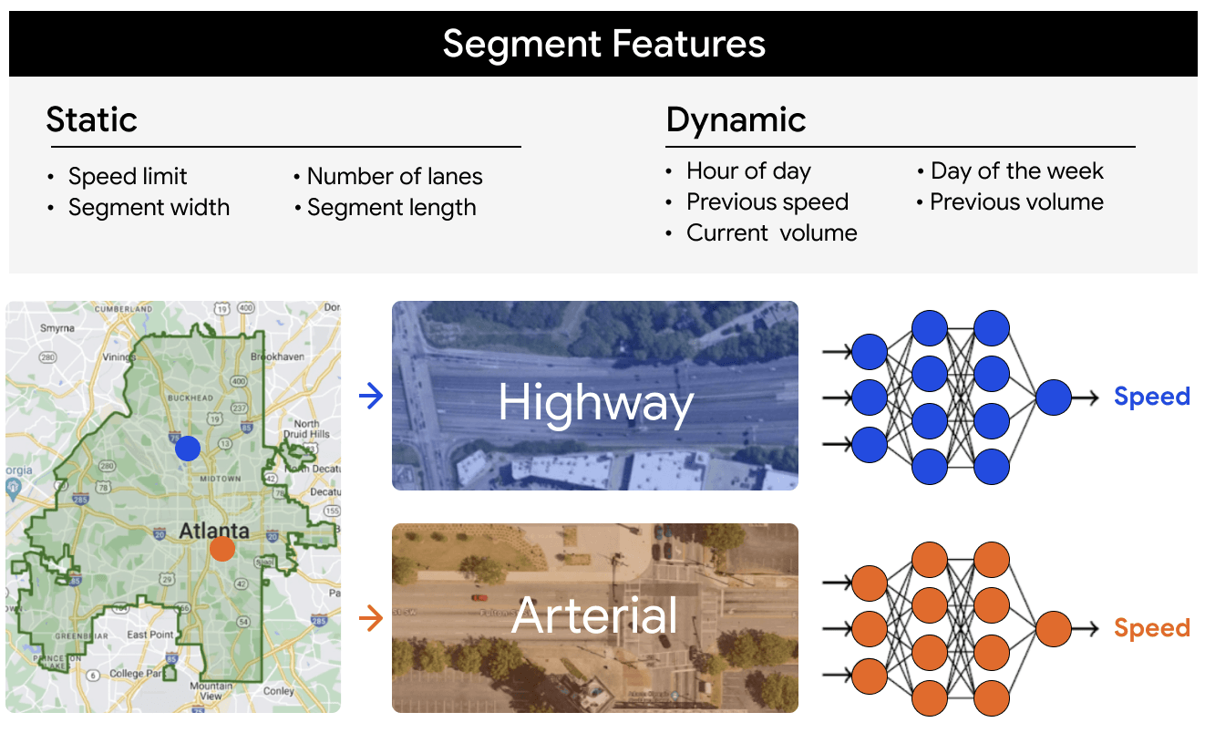
When accident data is layered onto these maps, it becomes easier to see where crashes happen most often and how traffic conditions may be contributing to them.
Anthony J. Vecchio, Esq. New Jersey DUI & Criminal Defense Attorney at Law Office of Anthony J. Vecchio, LLC, says, “Understanding how and where incidents occur can provide important context for evaluating road safety issues. Patterns in accident data often highlight areas where conditions may be contributing to repeated collisions.”
This information helps cities focus their safety efforts in the right places. Instead of spreading resources evenly across every road, they can target the areas where people are most at risk.
Improving Real-Time Traffic Management
Open accident data helps cities manage traffic more effectively when incidents happen. In busy urban areas, even a small crash can slow traffic across several roads. When accident information is shared quickly through open systems, traffic control centers can react faster and reduce disruption.
In an interview, Ken Fiedler, Founder of Fiedler Law, said, “Timely information can make a significant difference after an accident. When authorities and traffic teams receive accurate reports quickly, they are better positioned to respond and keep road conditions from becoming more dangerous.”
Traffic management teams often monitor road activity using sensors, cameras, and digital dashboards. When an accident is reported in real time, they can immediately adjust traffic signals, display warnings on digital road signs, or reroute traffic through alternate streets. These quick actions help prevent long traffic backups and reduce the chance of secondary accidents.
Navigation platforms also benefit from this open data. Apps used by drivers can update routes when accidents are reported, helping people avoid blocked roads and congested areas. This not only saves time but also improves safety because fewer vehicles approach the accident scene unexpectedly.
Public transportation systems also rely on this information. Bus routes and city transit networks can adjust schedules or reroute vehicles when an accident blocks a major road. This helps keep daily transportation running smoothly even when incidents occur.
Htet Aung Shine, Co-Founder of NextClinic, shares, “When real-time information is shared across systems, it becomes easier for organizations and communities to coordinate their response. Clear updates help people adapt quickly to changing situations.”
Supporting Data-Driven Road Safety Policies
Open accident data also plays a major role in shaping long-term road safety policies. When cities and transportation agencies collect detailed crash information over time, they can study patterns that reveal deeper safety problems. Instead of reacting to accidents one by one, officials can look at large datasets to understand where risks are increasing and what types of crashes happen most often.
Justin Schnitzer, Founder & Managing Partner at The Law Office of Justin Schnitzer, explains, “Accident data often reveals patterns that individual cases alone cannot show. When transportation officials and investigators review records across many incidents, it becomes easier to identify recurring risks and consider practical safety improvements.”
For example, transportation departments often review accident reports to identify common factors such as speeding, poor road design, or intersections where crashes repeatedly occur. When the same location appears again and again in accident data, it signals that something about that road needs attention. Cities can then redesign intersections, improve lighting, adjust traffic signals, or introduce speed-control measures.
Recent crash data shows how serious the issue remains. A nationwide overview of vehicle accident deaths in 2025 shows that more than 37,000 people lost their lives in road accidents across the United States.
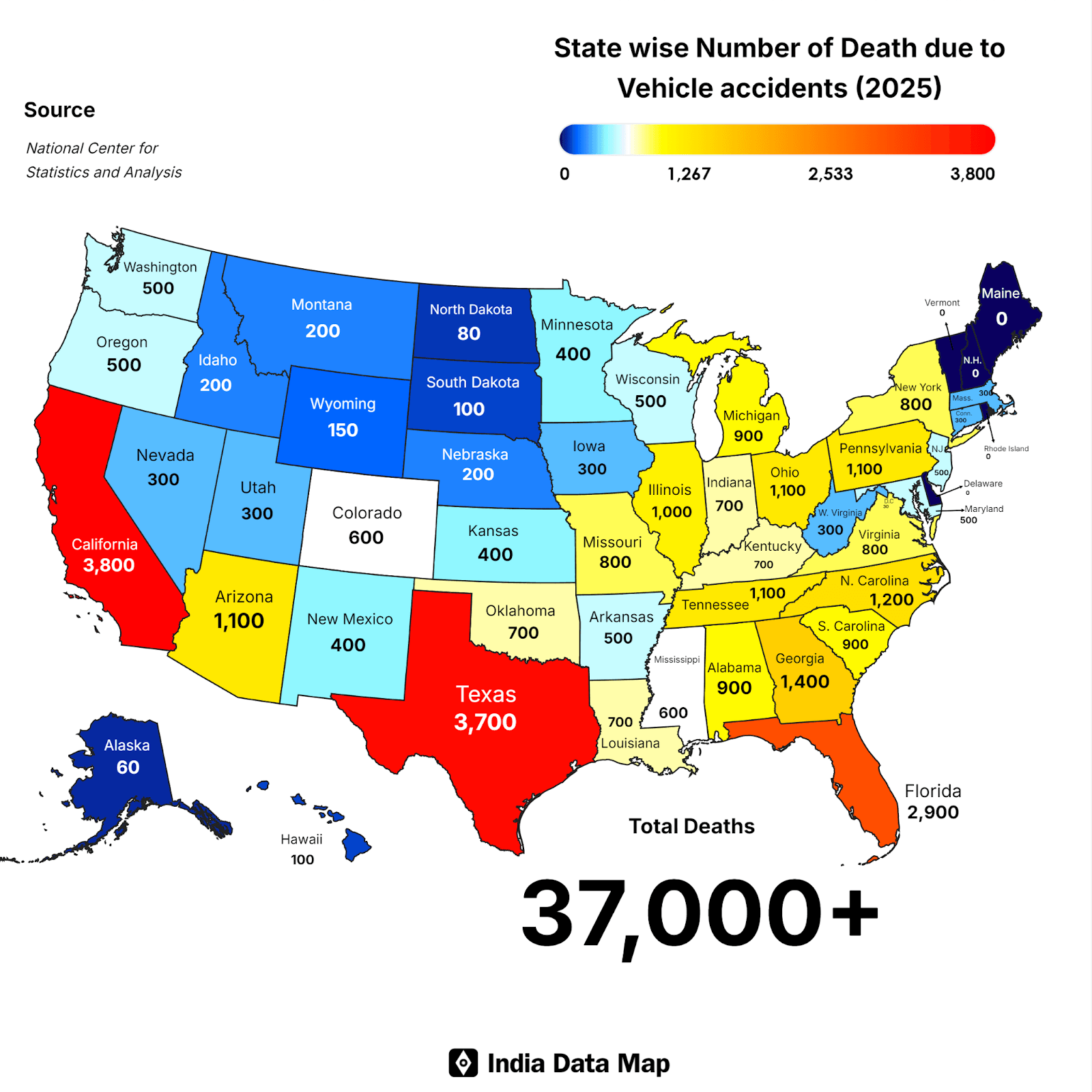
Some states recorded especially high numbers, including California with around 3,800 deaths, Texas with about 3,700, and Florida with roughly 2,900. These figures highlight why transportation departments rely heavily on crash data when making safety decisions.
“Reviewing accident trends across different regions often helps highlight areas where safety conditions may need closer attention. Data from multiple incidents can provide useful insight into how risks develop over time,” notes Alex Begum, Austin car crash attorneys at Texas Law Guns, Injury & Accident Lawyers.
When governments study accident data across states and cities, they gain a clearer understanding of where safety improvements are needed most. Open data allows policymakers, researchers, and urban planners to work with real information instead of assumptions when designing safer roads.
Improving Emergency Response Coordination
In a busy city, every minute matters after an accident. Police officers, ambulance teams, and firefighters all need accurate information about the location and severity of the crash so they can act quickly.
Bill Sanders, from TruePeopleSearch, says, “Access to verified information helps people understand situations more clearly. When records and reports are easy to locate, it becomes easier for different groups to review details and respond appropriately.”
When accident data is shared through open systems, emergency response centers can see incidents as they are reported. Digital maps and traffic monitoring systems allow dispatch teams to identify the exact location of a crash and determine the fastest route for emergency vehicles. This reduces delays and helps responders reach injured people sooner.
Open data systems also help different departments work together more smoothly. Police, medical teams, and traffic control centers can view the same information and coordinate their actions. For example, traffic teams can temporarily change signal timing or close certain lanes so ambulances can move through congested areas more easily.
Clear accident data also helps emergency services prepare for future incidents. By studying past crashes, cities can identify areas where emergency calls happen frequently and make sure medical resources are positioned nearby. This improves response time and helps ensure that injured people receive help as quickly as possible.
Timothy Allen, Sr. Corporate Investigator at Oberheiden P.C., shares, “When multiple teams rely on the same verified information, coordination becomes far more effective. Clear records and timely data often play a key role in helping professionals respond quickly during critical situations.”
Encouraging Transparency and Public Awareness
Open accident data also increases transparency for the public. When cities make crash information available, residents, researchers, and journalists can better understand what is happening on local roads. Instead of relying only on official statements, people can review the data themselves and see where accidents occur most often.
This transparency helps communities become more aware of road safety risks. If residents notice that crashes frequently happen near a school, busy intersection, or pedestrian crossing, they are more likely to raise concerns and push for safety improvements. Local advocacy groups often use accident data to support requests for better lighting, clearer crosswalks, or reduced speed limits.
According to Bill Sanders, from QuickPeopleLookup, “When information about incidents is clearly documented and accessible, it allows people to review details for themselves. Organized public records often make it easier for communities to understand patterns and stay informed.”
Researchers and universities also benefit from open crash data. By studying long-term accident patterns, they can identify trends related to driver behavior, traffic congestion, or urban design. These insights often help cities improve transportation policies and safety programs.
When accident data is openly available, it builds trust between the public and local governments. People can see how safety decisions are made and understand why certain infrastructure changes or traffic rules are introduced.
Supporting Long-Term Safety Planning
Open accident data also plays an important role in long-term safety planning. Cities increasingly rely on large datasets to understand how traffic patterns evolve and how those changes influence accident risks. When crash records are tracked over time, transportation planners can evaluate whether safety programs are improving conditions or if certain roads are becoming more dangerous.
Lindsay Redd, News Director, Local Accident Reports, explains, “Smart cities rely on transparent, accessible data to improve public systems. Crash data from Local Accident Reports contribute to that infrastructure by making crash information searchable and location-specific. Open accident data helps municipalities identify high-risk areas and implement targeted solutions. Digital reporting supports smarter urban planning. Data transparency is foundational to safer cities.”
By reviewing crash information year after year, planners gain a clearer understanding of where safety efforts are working and where new problems may be developing. This kind of long-term visibility allows cities to adjust infrastructure plans, update safety programs, and focus resources on the areas where residents face the greatest risks.
Seat belt statistics are a good example of how accident data helps guide public safety decisions. Around 10,484 passenger vehicle occupants who died in traffic crashes in 2023 were not wearing seat belts.
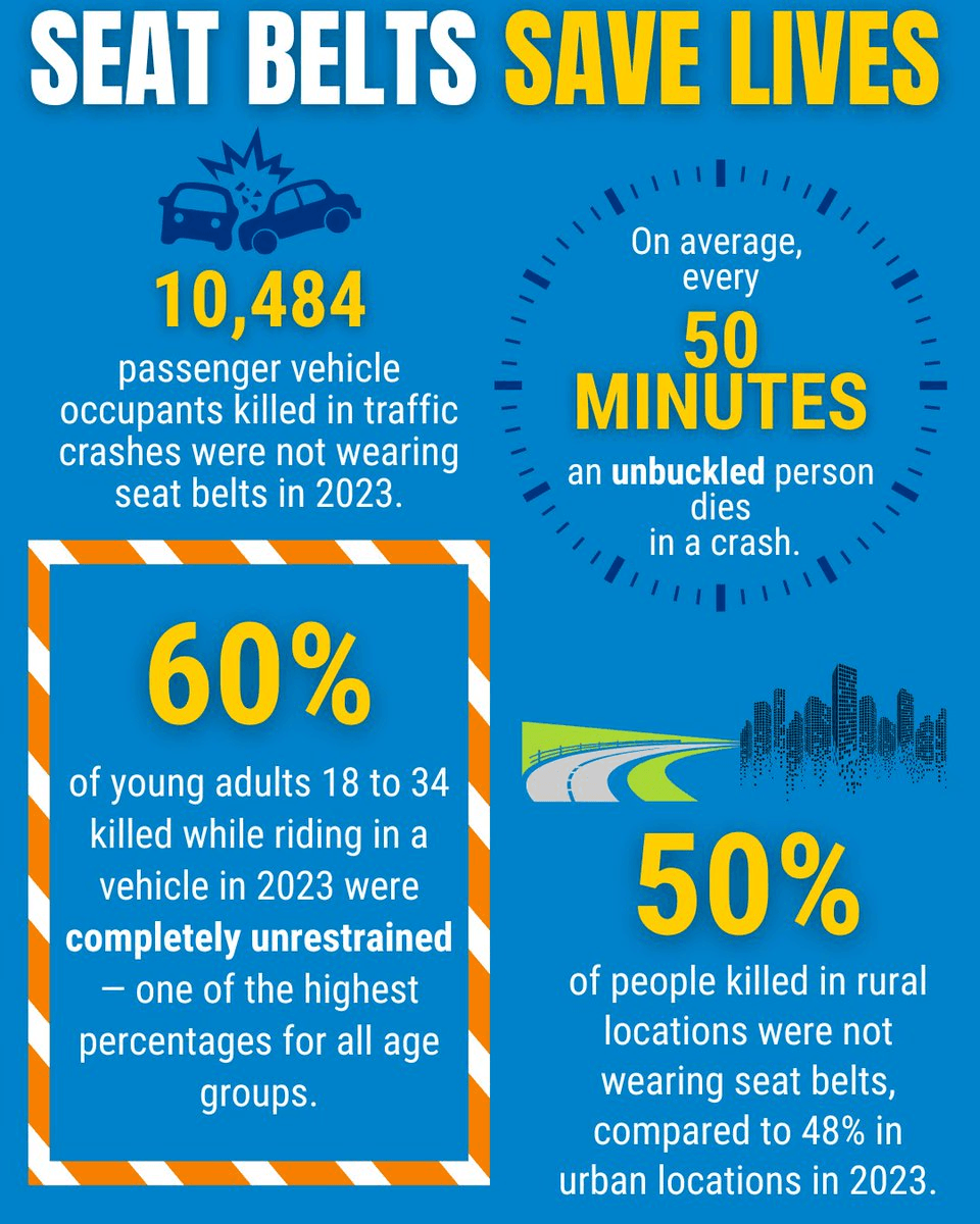
Data also shows that about 60% of young adults aged 18 to 34 who died in crashes were completely unrestrained, which is one of the highest rates among age groups.
Location also plays a role. Around 50% of people killed in rural crashes were not wearing seat belts, compared with 48% in urban areas. These numbers help transportation agencies understand where education campaigns, enforcement, and safety programs are most needed.
Wrap Up
Smart cities work best when decisions are based on real information. Open accident data gives city planners, safety officials, and researchers a clear view of what is happening on the roads. Instead of guessing where problems might exist, they can look at actual crash patterns and understand which areas need attention.
When this data is shared openly, it also helps emergency teams respond faster, supports better traffic management, and allows communities to stay informed about local safety risks. Over time, these insights help cities redesign dangerous roads, improve traffic systems, and reduce accidents.


