
resources
Unveiling the Biggest UK Cities by Area: A Comprehensive Guide
07 Mar 2026

When thoughts turn to the UK's most significant cities, one often conjures images of vibrant, densely populated metropolises. But have you ever considered their sheer physical expanse? We're delving into the actual land area these urban centers occupy—a fascinating, and sometimes surprising, lens through which to view urban development. This comprehensive guide will navigate the biggest UK cities by area, exploring how geographical factors shape their form and what that ultimately means for the myriad individuals who call them home. Let's embark on this insightful journey.
Key Takeaways
- England, particularly regions such as Greater London and the South East, typically exhibits the most expansive urban footprints, a characteristic largely attributable to its high population density and extensive historical development.
- Scotland's impressive, often mountainous topography fundamentally influences the scale and distribution of its urban settlements, with distinctive geographic features playing a truly significant role in their formation.
- Wales's unique landscape, distinguished by its majestic mountains—think Snowdonia—and an extensive coastline, profoundly impacts how its cities are conceived and the amount of land they ultimately occupy.
- Northern Ireland's urban areas are intricately shaped by its specific geographic attributes, encompassing factors like coastal proximity and the broader topography inherent to the region.
- To effectively compare the biggest UK cities by area, one must appreciate the nuances of various measurement methodologies; while population is certainly a factor, it doesn't invariably correlate directly with a city's sheer geographic magnitude.
Understanding the Scale of UK Cities
When we refer to a city as "biggest," it's often an instinctive reaction to consider population figures. However, what about the physical territory a city encompasses—the sheer geographic footprint? That, as it turns out, is a completely different narrative, one that reveals much about a city's origins, its subsequent growth, and the intricate ways people interact with their environment. It’s not simply a question of how many residents reside there, but rather how spatially distributed they are, and indeed, the kind of landscape they inhabit.
Defining City Boundaries for Area Measurement
Pinpointing the precise area of a city isn't always a straightforward exercise. Unlike, say, a clearly demarcated property plot, city boundaries can often be quite fluid. Are we referring to the official administrative city limits, the core densely built-up urban area, or perhaps a broader metropolitan region that includes surrounding towns and the commuter belt? Each definition, naturally, paints a distinct picture. For the purposes of this guide, we'll primarily focus on official administrative boundaries wherever feasible, but it's always wise to remember that the "functional" city frequently extends well beyond these lines.
The Importance of Geographic Size in Urban Studies
So, why is a city's area worth bothering with? Well, its impact ripples through everything from intricate infrastructure planning to vital environmental studies. A city that sprawls across a vast expanse, for instance, might necessitate very different transportation solutions compared to a more compact urban center. It can also influence the availability of green spaces, dictate housing density, and even affect how local weather patterns manifest. Understanding this physical scale is truly fundamental—it helps us grasp the profound complexities of modern urban living and strategic planning.
Key Factors Influencing City Area
A multitude of elements converge to shape the geographical extent of a city:
- Historical Development: Older urban centers often expanded organically, with their boundaries historically defined by ancient fortifications or natural geographic features. Newer cities, by contrast, might have been planned with considerably more scope for expansion.
- Geography and Topography: Features such as mountains, major rivers, or coastlines can either restrict or channel a city's growth. A city encircled by mountains, for example, might develop vertically or predominantly within specific valleys.
- Administrative Decisions: Local government boundaries are frequently established for political or administrative expediency, which may not always perfectly align with the actual built-up area of a city.
- Economic Growth and Planning: Periods of significant economic expansion can precipitate cities annexing adjacent land or fostering the development of new suburbs, thereby substantially increasing their overall footprint.
England's Dominance in Urban Sprawl
When the conversation turns to the sheer scale of urban areas within the UK, England unequivocally stands out. It's not merely a matter of population figures; it's about the tangible physical space these cities, and their encompassing regions, command. A substantial portion of this phenomenon is rooted in history—the Industrial Revolution, for instance, dramatically accelerated urban expansion—and also in the country's inherent geographical layout.
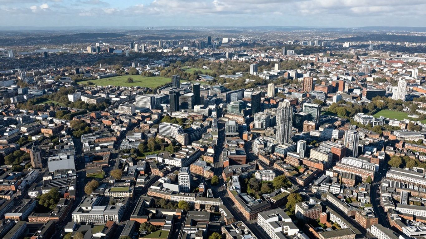
Greater London's Extensive Footprint
Greater London is, beyond any shadow of a doubt, the preeminent force concerning urban area size across the UK. It represents a colossal conurbation that has consistently expanded outwards over many centuries. Its sheer magnitude means it exerts an immense influence on the surrounding regions, attracting countless individuals for employment and generating an expansive economic zone. Moreover, the population density here is extraordinarily high, which quite naturally contributes to its significant physical footprint.
South East England's Metropolitan Reach
Beyond the capital, the South East region of England is another locale where urban sprawl is remarkably conspicuous. This region hosts numerous towns and cities that have experienced considerable growth, often gradually coalescing into larger, interconnected urban areas. Consider the extensive commuter belt encircling London—it stretches far and wide, seamlessly linking countless communities into one vast, interdependent metropolitan zone. This pervasive interconnectedness implies that even smaller towns can feel intrinsically part of a much grander urban tapestry.
The Vastness of the South West Region
The South West of England presents an intriguing contrast, possessing a different kind of vastness. While it may not rival the South East in terms of population density, its administrative and geographical boundaries frequently enclose substantial rural areas alongside its cities. This characteristic can make the officially defined urban areas appear more expansive on a map, even if the built-up environment isn't as continuous or unbroken as in other parts of the country. It's a region where cities are often more spread out, their development frequently shaped by historical trade routes and the distinctive natural landscape.
The precise methodology employed to measure city areas can truly reshape our perception of them. Sometimes, official boundaries deliberately incorporate significant green spaces or less developed land, consequently making the total area seem larger than just the built-up core. This is particularly evident in regions characterized by highly varied geography.
Here's a concise overview of how some regions compare in terms of land area and population density:
| Region | Land Area (km²) | Population Density (/km²) |
|---|---|---|
| Greater London | 1,572 | 5,640 |
| South East | 19,072 | 492 |
| South West | 23,836 | 242 |
| England (Total) | 130,310 | 438 |
Scotland's Expansive Urban Landscapes
When the discussion turns to the sheer size of UK cities, Scotland frequently introduces a distinct perspective. It's not merely about understanding dense population centers; it's crucially about how urban areas dynamically interact with a vast and incredibly varied geography. Think of it this way: Scotland's landmass is considerable, and its cities, while perhaps not as numerous or as sprawling as some in England, often maintain a unique, almost symbiotic relationship with their encompassing surroundings.
The Highlands and Islands' Geographic Influence
The sheer scale of the Highlands and Islands region plays an immense role in how we define and subsequently measure urban areas across Scotland. In stark contrast to the more densely populated sections of the UK, vast swathes of Scotland remain sparsely inhabited. This implies that even a city with a relatively modest population might administratively encompass a considerable land area, extending to include its surrounding rural hinterland, various commuter towns, and even significant natural landscapes. This expansive approach to delineating city boundaries can, at times, render direct comparisons with other UK cities a tad complex, particularly if one is focusing solely on raw acreage.
- Extensive natural reserves frequently fall within official administrative city limits.
- Lower population density naturally translates to more land available per person.
- Connectivity and robust infrastructure development are paramount considerations within these expansive areas.
Urban Settlements in Scotland's Diverse Terrain
Scotland's urban settlements are strategically distributed across an incredibly diverse landscape—from the industrial legacy of the central belt to the more remote charm of its coastal towns. The size of these cities isn't just about the built-up zones; it very often includes the land essential to their sustenance, whether that be fertile agricultural land, extensive forestry, or critically, protected natural spaces. This intrinsic integration of natural and urban environments—a truly distinctive characteristic—is a defining hallmark of Scottish urban planning.
The methodology for measuring Scotland's cities frequently reflects a delicate balance between encouraging urban development and, equally importantly, preserving its unparalleled natural beauty. This can lead to official city areas that are considerably larger than might be anticipated based solely on population metrics.
Here's an overview of how some Scottish cities might be assessed in terms of their land area, always keeping in mind the significant influence of their geography:
| City | Approximate Area (sq km) | Key Geographic Feature Influencing Area |
|---|---|---|
| Glasgow | ~170 | Clyde Valley, surrounding hills |
| Edinburgh | ~264 | Pentland Hills, Firth of Forth coast |
| Aberdeen | ~186 | North Sea coast, River Dee |
| Inverness | ~150 | Moray Firth, Great Glen |
Wales's Mountainous and Coastal Cities
The Impact of Snowdonia on Urban Planning
When one contemplates Wales, the immediate image that often springs to mind is its dramatically beautiful landscape. Mountains, after all, constitute a substantial portion of the country, particularly in its northern and central regions. Snowdonia National Park, for instance, is an enormous expanse of rugged peaks and deep valleys. This distinctive terrain profoundly shapes how cities and towns inevitably develop. Constructing roads, residential areas, and essential infrastructure becomes considerably more intricate—and costly—when navigating steep inclines and rocky ground. Consequently, urban areas in Wales tend to be more dispersed or snugly nestled into valleys, rather than sprawling outwards without restraint, as might be observed in flatter parts of the UK. This natural barrier has, quite historically, dictated where communities chose to settle and how they subsequently expanded.
Coastal Cities and Their Land Area Considerations
Wales also boasts a remarkably long and intricate coastline, stretching over 1,600 miles. This geographical feature means that a significant number of its cities and towns are, by definition, coastal. Consider major centers like Swansea or Cardiff. Their proximity to the sea has historically been pivotal for both trade and industry, but it also directly influences their physical dimensions. Coastal cities frequently face the challenge of limited land for expansion, hemmed in by the sea on one side and potentially hills or mountains on the other. This often results in denser development within specific zones. Furthermore, with the ongoing concerns of climate change and rising sea levels, strategic coastal planning is becoming an even more critical consideration for these Welsh urban centers.
Here’s a snapshot of how some prominent Welsh cities integrate with the country's unique geography:
- Cardiff: As the capital city, located in the south, it presents a compelling blend of urban development and direct coastal access. Its geographical area is significantly influenced by its position near the Bristol Channel.
- Swansea: Situated directly on the coast in South Wales, Swansea's urban footprint is intricately shaped by both the bay and the surrounding hilly terrain.
- Newport: Another important city in the south, its development is inextricably linked to its historical port and its strategic location near the estuary of the River Usk.
The predominantly mountainous character of Wales means that extensive, unbroken urban areas are less common here compared to more level regions. Instead, settlements are typically found within river valleys or along the coastline, with substantial natural landscapes serving as natural separators between them.
Northern Ireland's Urban Footprint
The Geographic Characteristics of Northern Ireland's Cities
Northern Ireland, while being the smallest of the UK's constituent countries by land area, possesses a landscape that profoundly influences its urban development patterns. It is a region characterized by undulating hills, significant loughs (lakes), and a distinctive coastline—all of which play a role in determining where people choose to settle and how cities grow. Unlike some of the flatter expanses of Great Britain, the terrain here very often dictates the ultimate size and configuration of its urban areas.
The total land area of Northern Ireland is approximately 5,470 square miles (14,160 square kilometers). This figure encompasses not just the built-up areas but also vast stretches of countryside, including major bodies of water such as Lough Neagh, which holds the distinction of being the largest lake in the British Isles. This implies that when we discuss the 'area' of its cities, we are frequently referring to administrative boundaries that often include a substantial amount of undeveloped land.
Here's a closer look at how geography plays a pivotal role:
- Hilly Terrain: Much of Northern Ireland is defined by its hills and mountains, like the iconic Mourne Mountains. This topographical feature can render large, contiguous urban sprawl more challenging, often leading to settlements being snugly situated in valleys or strategically along coastlines.
- Water Features: The presence of expansive loughs, notably Lough Neagh and Lough Erne, effectively divides the landscape and significantly influences both transportation routes and settlement patterns. These extensive water bodies themselves constitute a considerable portion of the country's total area.
- Coastal Influence: The extensive coastline provides natural harbors and has historically served as a critical focal point for trade and settlement, consequently fostering the development of numerous port cities and towns.
Coastal Influence on Urban Development
The coast of Northern Ireland is undoubtedly a defining geographical feature, impacting everything from its rich history to its contemporary urban layout. Many of its most significant cities and towns are strategically positioned along this edge, historically benefiting from access to the sea for trade, fishing, and, more recently, for tourism.
Belfast, the capital and largest city, is ideally situated at the mouth of the River Lagan, on the picturesque shores of Belfast Lough. Its considerable growth was intrinsically linked to its prowess in shipbuilding and extensive port activities, a heritage that has profoundly shaped its industrial past and continues to influence its current urban form. Similarly, cities like Derry/Londonderry, with its historic walls overlooking the River Foyle, exhibit a powerful and enduring connection to their coastal and riverine environments.
The intricate interplay between the land and the sea has, throughout history, been a primary guide in determining where communities formed and how they subsequently expanded. This pervasive coastal proximity continues to shape both economic activities and the physical layout of urban centers across Northern Ireland today—a truly defining characteristic.
While Northern Ireland may not exhibit the sheer scale of urban areas observed in some other parts of the UK, its unique geography has undeniably sculpted distinctive urban landscapes. The size of its cities often serves as a direct reflection of the natural features that envelop them, fostering a unique character intrinsically tied to its island environment.
Comparing Urban Areas Across the UK
Methodologies for Measuring City Area
When we discuss the "size" of a city, the calculation isn't always as straightforward as one might initially presume. Different regions, understandably, employ various methods to measure their urban areas, which can render direct comparisons somewhat complex. Some approaches might focus on administrative boundaries—essentially, the official line drawn around the city hall and its immediate service purview. Others consider the 'built-up area,' encompassing all continuously developed land, even if it extends into neighboring towns or villages. Then, there's the 'urban agglomeration,' a broader definition that frequently includes the main city plus its surrounding commuter towns and suburbs that are robustly linked both economically and socially. Grasping these diverse measurement methods is absolutely crucial for making sense of why city areas can appear so varied across different analyses.
The Relationship Between Population and Area
It's quite natural to assume that larger cities will inherently host more people, and indeed, this is generally the case. However, the correlation isn't always a simple one-to-one relationship. Some cities, for example, might concentrate a vast population into a relatively compact area, resulting in exceptionally high population densities. Think of places like London, where an immense number of individuals live and work within a highly concentrated space. Conversely, you'll find cities that encompass a much larger geographical footprint but exhibit a lower population density. This often occurs in regions where land is more readily available, or where historical development patterns fostered more spread-out settlements. Ultimately, it's a dynamic interplay between how many people call a place home and the extent of the land they collectively occupy.
Identifying the Largest Cities by Area
So, which UK cities genuinely command the most space? While population figures frequently capture the headlines, an examination of sheer land area offers a distinct perspective on urban scale. It’s not just about the number of residents; it’s about how far the urban footprint truly extends. This can be influenced by a myriad of factors, including the local geography, historical urban planning decisions, and prevailing economic development trends.
Here's an overview illustrating how some major UK urban areas stack up in terms of their geographical size:
| Rank | Name | Approximate Area (km²) |
|---|---|---|
| 1 | Greater London | 1,572 |
| 2 | South West Region* | 23,836 |
| 3 | East of England* | 19,116 |
| 4 | South East | 19,072 |
| 5 | East Midlands* | 15,624 |
Note: Some entries represent broader regions that contain significant urban centers, reflecting how administrative and geographical definitions can overlap.
The sheer magnitude of certain urban areas, particularly when considering broader definitions that encompass surrounding regions or extensive administrative boundaries, powerfully underscores the diverse nature of urban development throughout the United Kingdom. It serves as a potent reminder that the term 'city' can carry a multitude of meanings, depending entirely on the specific context and the measurement methodology employed.
Wrapping Up Our City Exploration
So, we've taken a fascinating tour, examining some of the UK's biggest cities based on the sheer physical space they occupy. It's quite interesting to observe just how much size can fluctuate, isn't it? Some urban centers might indeed be vast in terms of land area but don't necessarily have their populations packed quite as densely, while others are remarkably compact yet intensely populated. This kind of nuanced information truly helps to paint a clearer, more comprehensive picture of the UK's diverse landscape and the intricate structures of its various urban areas. It's not merely about crunching numbers; it's fundamentally about understanding the tangible physical footprint these places leave. Hopefully, this guide has provided you with a robust sense of the scale involved when we discuss the UK's largest cities by area.
Frequently Asked Questions
What is the largest city in the UK by area?
When we consider cities based on their total land size, it's crucial to acknowledge that definitions can vary significantly. However, broadly speaking, Greater London boasts the most extensive geographical footprint. It covers a substantial amount of territory, firmly establishing it as the largest urban area across the UK.
Does England have the biggest cities in the UK?
Yes, in general, England tends to be home to the largest cities when measured by area. This phenomenon is partly attributable to its substantial population and the historical manner in which its major urban centers have expanded over time, progressively spreading into surrounding regions. Areas like the South East and the South West, for instance, exhibit particularly expansive urban sprawls.
How does Scotland's geography affect its city sizes?
Scotland's distinctive landscape, characterized by its majestic mountains and numerous islands, plays a significant role in determining how its cities are spatially arranged. While some urban centers are situated in flatter, more accessible areas, the rugged terrain often means that cities may not spread out as extensively as they do in flatter parts of England. The Highlands, for example, exert a profound influence on where communities can feasibly settle and build.
Are Wales's cities affected by mountains and coastlines?
Absolutely! Wales is notably mountainous, especially in iconic regions like Snowdonia. This natural landscape directly shapes where cities can be established and how they ultimately grow. Furthermore, coastal cities in Wales must carefully consider both the sea and their inherent connection to it when strategically planning their size and development—it's a fundamental aspect of their urban identity.
What makes Northern Ireland's cities unique in terms of area?
Northern Ireland's cities are distinctly influenced by its unique geography, which encompasses both extensive coastlines and gently rolling hills. The overall land area available for development, coupled with specific geographical features—such as proximity to the sea—are crucial factors that help to define the size and unique shape of its urban centers, creating a truly distinct character.
Is there a standard way to measure the size of a city?
Measuring the precise size of a city isn't always a uniform process. Different studies and organizations might employ varying methodologies, such as examining a city's administrative boundaries, its 'built-up area' (referring to continuously connected structures), or its wider metropolitan region. This inherent variability is precisely why you might encounter different figures depending on your source of information.


